Saint-Maugan
Saint-Maugan
Sant-Malgant | |
|---|---|
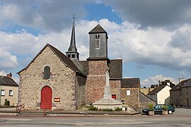 The church of Saint-Maugan | |
 Coat of arms | |
show Location of Saint-Maugan | |
 Saint-Maugan | |
| Coordinates: 48°08′09″N 2°04′56″W / 48.1358°N 2.0822°WCoordinates: 48°08′09″N 2°04′56″W / 48.1358°N 2.0822°W | |
| Country | France |
| Region | Brittany |
| Department | Ille-et-Vilaine |
| Arrondissement | Rennes |
| Canton | Montauban-de-Bretagne |
| Intercommunality | Saint-Méen Montauban |
| Government | |
| • Mayor (2014–2020) | Claude Trubert |
| Area 1 | 8.43 km2 (3.25 sq mi) |
| Population (Jan. 2018)[1] | 537 |
| • Density | 64/km2 (160/sq mi) |
| Time zone | UTC+01:00 (CET) |
| • Summer (DST) | UTC+02:00 (CEST) |
| INSEE/Postal code | 35295 /35750 |
| Elevation | 42–98 m (138–322 ft) |
| 1 French Land Register data, which excludes lakes, ponds, glaciers > 1 km2 (0.386 sq mi or 247 acres) and river estuaries. | |


Saint-Maugan (Breton: Sant-Malgant, Gallo: Saent-Maugant) is a commune in the Ille-et-Vilaine department in Brittany in northwestern France.
Geography[]
The commune is traversed by the Meu river.
Population[]
Inhabitants of Saint-Maugan are called malganais in French.
| Year | Pop. | ±% |
|---|---|---|
| 1962 | 315 | — |
| 1968 | 363 | +15.2% |
| 1975 | 322 | −11.3% |
| 1982 | 321 | −0.3% |
| 1990 | 384 | +19.6% |
| 1999 | 349 | −9.1% |
| 2009 | 565 | +61.9% |
See also[]
- Communes of the Ille-et-Vilaine department
References[]
- ^ "Populations légales 2018". INSEE. 28 December 2020.
External links[]
| Wikimedia Commons has media related to Saint-Maugan. |
- Mayors of Ille-et-Vilaine Association (in French)
| show Communes of the Ille-et-Vilaine department |
|---|
| show Authority control |
|---|
This Ille-et-Vilaine geographical article is a stub. You can help Wikipedia by . |
Categories:
- Communes of Ille-et-Vilaine
- Ille-et-Vilaine geography stubs