Landujan
Landujan
Landujan | |
|---|---|
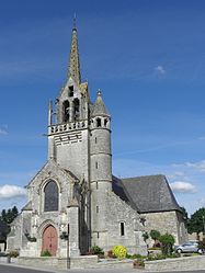 The parish church of Saint-Tudin | |
 Coat of arms | |
show Location of Landujan | |
 Landujan | |
| Coordinates: 48°15′03″N 1°59′42″W / 48.2508°N 1.995°WCoordinates: 48°15′03″N 1°59′42″W / 48.2508°N 1.995°W | |
| Country | France |
| Region | Brittany |
| Department | Ille-et-Vilaine |
| Arrondissement | Rennes |
| Canton | Montauban-de-Bretagne |
| Intercommunality | Saint-Méen Montauban |
| Government | |
| • Mayor (2014–2020) | Annie Matuszak |
| Area 1 | 14.32 km2 (5.53 sq mi) |
| Population (Jan. 2018)[1] | 911 |
| • Density | 64/km2 (160/sq mi) |
| Time zone | UTC+01:00 (CET) |
| • Summer (DST) | UTC+02:00 (CEST) |
| INSEE/Postal code | 35143 /35360 |
| Elevation | 62–118 m (203–387 ft) |
| 1 French Land Register data, which excludes lakes, ponds, glaciers > 1 km2 (0.386 sq mi or 247 acres) and river estuaries. | |


Landujan (Breton: Landujan, Gallo: Landujan) is a commune in the Ille-et-Vilaine department in Brittany in northwestern France.
Population[]
Inhabitants of Landujan are called Landujannais in French.
| Year | Pop. | ±% |
|---|---|---|
| 1962 | 634 | — |
| 1968 | 680 | +7.3% |
| 1975 | 618 | −9.1% |
| 1982 | 589 | −4.7% |
| 1990 | 640 | +8.7% |
| 1999 | 683 | +6.7% |
| 2008 | 930 | +36.2% |
See also[]
- Communes of the Ille-et-Vilaine department
References[]
- ^ "Populations légales 2018". INSEE. 28 December 2020.
External links[]
| Wikimedia Commons has media related to Landujan. |
- Mayors of Ille-et-Vilaine Association (in French)
| show Communes of the Ille-et-Vilaine department |
|---|
This Ille-et-Vilaine geographical article is a stub. You can help Wikipedia by . |
Categories:
- Communes of Ille-et-Vilaine
- Ille-et-Vilaine geography stubs