Cintré
Cintré
Kentreg | |
|---|---|
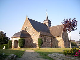 Saint Melaine church | |
show Location of Cintré | |
 Cintré | |
| Coordinates: 48°06′20″N 1°52′20″W / 48.1055°N 1.8722°WCoordinates: 48°06′20″N 1°52′20″W / 48.1055°N 1.8722°W | |
| Country | France |
| Region | Brittany |
| Department | Ille-et-Vilaine |
| Arrondissement | Rennes |
| Canton | Le Rheu |
| Intercommunality | Rennes Métropole |
| Government | |
| • Mayor (2020–2026) | Jacques Ruello[1] |
| Area 1 | 8.24 km2 (3.18 sq mi) |
| Population (Jan. 2018)[2] | 2,344 |
| • Density | 280/km2 (740/sq mi) |
| Time zone | UTC+01:00 (CET) |
| • Summer (DST) | UTC+02:00 (CEST) |
| INSEE/Postal code | 35080 /35310 |
| Elevation | 25–63 m (82–207 ft) |
| 1 French Land Register data, which excludes lakes, ponds, glaciers > 1 km2 (0.386 sq mi or 247 acres) and river estuaries. | |


Cintré (French pronunciation: [sɛ̃tʁe]; Breton: Kentreg; Gallo: Ceintraé) is a commune in the Ille-et-Vilaine department of Brittany in northwestern France.
Geography[]
The river Meu forms all of the commune's western border.
Population[]
Inhabitants of Cintré are called Cintréens in French.
| Year | Pop. | ±% |
|---|---|---|
| 1962 | 520 | — |
| 1968 | 533 | +2.5% |
| 1975 | 857 | +60.8% |
| 1982 | 1,069 | +24.7% |
| 1990 | 1,170 | +9.4% |
| 1999 | 1,467 | +25.4% |
| 2008 | 2,061 | +40.5% |
See also[]
- Communes of the Ille-et-Vilaine department
References[]
- ^ "Répertoire national des élus: les maires". data.gouv.fr, Plateforme ouverte des données publiques françaises (in French). 2 December 2020.
- ^ "Populations légales 2018". INSEE. 28 December 2020.
External links[]
| Wikimedia Commons has media related to Cintré. |
- Official website (in French)
- Base Mérimée: Search for heritage in the commune, Ministère français de la Culture. (in French)
- Mayors of Ille-et-Vilaine Association (in French)
| show Communes of the Ille-et-Vilaine department |
|---|
This Ille-et-Vilaine geographical article is a stub. You can help Wikipedia by . |
Categories:
- Communes of Ille-et-Vilaine
- Ille-et-Vilaine geography stubs