Saint-Marcan
Saint-Marcan | |
|---|---|
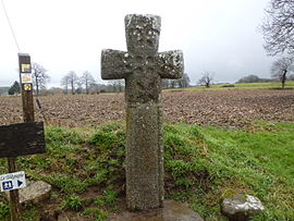 Old Medieval Cross | |
show Location of Saint-Marcan | |
 Saint-Marcan | |
| Coordinates: 48°35′19″N 1°37′56″W / 48.5886°N 1.6322°WCoordinates: 48°35′19″N 1°37′56″W / 48.5886°N 1.6322°W | |
| Country | France |
| Region | Brittany |
| Department | Ille-et-Vilaine |
| Arrondissement | Saint-Malo |
| Canton | Dol-de-Bretagne |
| Government | |
| • Mayor (2020–2026) | Louis Leport[1] |
| Area 1 | 7.68 km2 (2.97 sq mi) |
| Population (Jan. 2018)[2] | 442 |
| • Density | 58/km2 (150/sq mi) |
| Time zone | UTC+01:00 (CET) |
| • Summer (DST) | UTC+02:00 (CEST) |
| INSEE/Postal code | 35291 /35120 |
| Elevation | 4–96 m (13–315 ft) |
| 1 French Land Register data, which excludes lakes, ponds, glaciers > 1 km2 (0.386 sq mi or 247 acres) and river estuaries. | |


Saint-Marcan (French pronunciation: [sɛ̃ maʁkɑ̃]; Breton: Sant-Marc'han) is a commune in the Ille-et-Vilaine department in Brittany in northwestern France.
Population[]
Inhabitants of Saint-Marcan are called marcanais in French.
| Year | Pop. | ±% |
|---|---|---|
| 1962 | 537 | — |
| 1968 | 544 | +1.3% |
| 1975 | 453 | −16.7% |
| 1982 | 398 | −12.1% |
| 1990 | 401 | +0.8% |
| 1999 | 380 | −5.2% |
| 2009 | 455 | +19.7% |
Sights[]
- Menhir
- Medieval Christian Cross
- Chappe Tower
See also[]
- Communes of the Ille-et-Vilaine department
References[]
- ^ "Répertoire national des élus: les maires". data.gouv.fr, Plateforme ouverte des données publiques françaises (in French). 2 December 2020.
- ^ "Populations légales 2018". INSEE. 28 December 2020.
External links[]
| Wikimedia Commons has media related to Saint-Marcan. |
- Base Mérimée: Search for heritage in the commune, Ministère français de la Culture. (in French)
- Mayors of Ille-et-Vilaine Association (in French)
| show Communes of the Ille-et-Vilaine department |
|---|
This Ille-et-Vilaine geographical article is a stub. You can help Wikipedia by . |
Categories:
- Communes of Ille-et-Vilaine
- Ille-et-Vilaine geography stubs