Châteauroux-les-Alpes
Châteauroux-les-Alpes
Chasteurós (Occitan) | |
|---|---|
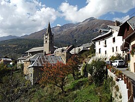 The village of Saint-Marcellin, in Châteauroux-les-Alpes | |
 Coat of arms | |
show Location of Châteauroux-les-Alpes | |
 Châteauroux-les-Alpes | |
| Coordinates: 44°36′55″N 6°31′21″E / 44.6153°N 6.5225°ECoordinates: 44°36′55″N 6°31′21″E / 44.6153°N 6.5225°E | |
| Country | France |
| Region | Provence-Alpes-Côte d'Azur |
| Department | Hautes-Alpes |
| Arrondissement | Gap |
| Canton | Embrun |
| Government | |
| • Mayor (2020–2026) | Jean-Marie Barral[1] |
| Area 1 | 92.84 km2 (35.85 sq mi) |
| Population (Jan. 2018)[2] | 1,193 |
| • Density | 13/km2 (33/sq mi) |
| Time zone | UTC+01:00 (CET) |
| • Summer (DST) | UTC+02:00 (CEST) |
| INSEE/Postal code | 05036 /05380 |
| Elevation | 811–3,120 m (2,661–10,236 ft) (avg. 928 m or 3,045 ft) |
| 1 French Land Register data, which excludes lakes, ponds, glaciers > 1 km2 (0.386 sq mi or 247 acres) and river estuaries. | |


Châteauroux-les-Alpes (French: [ʃɑtoʁu lez‿alp]; Occitan: Chasteurós) is a commune in the Hautes-Alpes department in southeastern France.
Population[]
| Year | Pop. | ±% |
|---|---|---|
| 1962 | 630 | — |
| 1968 | 683 | +8.4% |
| 1975 | 578 | −15.4% |
| 1982 | 649 | +12.3% |
| 1990 | 766 | +18.0% |
| 1999 | 927 | +21.0% |
| 2008 | 1,110 | +19.7% |
See also[]
- Communes of the Hautes-Alpes department
References[]
- ^ "Répertoire national des élus: les maires". data.gouv.fr, Plateforme ouverte des données publiques françaises (in French). 2 December 2020.
- ^ "Populations légales 2018". INSEE. 28 December 2020.
| Wikimedia Commons has media related to Châteauroux-les-Alpes. |
This Hautes-Alpes geographical article is a stub. You can help Wikipedia by . |
Categories:
- Communes of Hautes-Alpes
- Caturiges
- Hautes-Alpes geography stubs