Pelleautier
Pelleautier | |
|---|---|
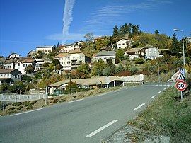 A view of the road entering the village of Pelleautier | |
 Coat of arms | |
show Location of Pelleautier | |
 Pelleautier | |
| Coordinates: 44°31′04″N 6°01′02″E / 44.5178°N 6.0172°ECoordinates: 44°31′04″N 6°01′02″E / 44.5178°N 6.0172°E | |
| Country | France |
| Region | Provence-Alpes-Côte d'Azur |
| Department | Hautes-Alpes |
| Arrondissement | Gap |
| Canton | Tallard |
| Government | |
| • Mayor (2020–2026) | Christian Hubaud[1] |
| Area 1 | 12.81 km2 (4.95 sq mi) |
| Population (Jan. 2018)[2] | 731 |
| • Density | 57/km2 (150/sq mi) |
| Time zone | UTC+01:00 (CET) |
| • Summer (DST) | UTC+02:00 (CEST) |
| INSEE/Postal code | 05100 /05000 |
| Elevation | 737–2,016 m (2,418–6,614 ft) (avg. 925 m or 3,035 ft) |
| 1 French Land Register data, which excludes lakes, ponds, glaciers > 1 km2 (0.386 sq mi or 247 acres) and river estuaries. | |


Pelleautier (French pronunciation: [pɛlotje]; Occitan: Pelautier) is a commune in the Hautes-Alpes department in southeastern France.
Population[]
| Year | Pop. | ±% |
|---|---|---|
| 1962 | 200 | — |
| 1968 | 206 | +3.0% |
| 1975 | 230 | +11.7% |
| 1982 | 321 | +39.6% |
| 1990 | 378 | +17.8% |
| 1999 | 391 | +3.4% |
| 2008 | 557 | +42.5% |
See also[]
- Communes of the Hautes-Alpes department
References[]
- ^ "Répertoire national des élus: les maires". data.gouv.fr, Plateforme ouverte des données publiques françaises (in French). 2 December 2020.
- ^ "Populations légales 2018". INSEE. 28 December 2020.
| Wikimedia Commons has media related to Pelleautier. |
This Hautes-Alpes geographical article is a stub. You can help Wikipedia by . |
Categories:
- Communes of Hautes-Alpes
- Hautes-Alpes geography stubs