Savines-le-Lac
Savines-le-Lac | |
|---|---|
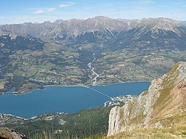 Savines and the Lac de Serre-Ponçon | |
 Coat of arms | |
show Location of Savines-le-Lac | |
 Savines-le-Lac | |
| Coordinates: 44°31′37″N 6°24′20″E / 44.5269°N 6.4056°ECoordinates: 44°31′37″N 6°24′20″E / 44.5269°N 6.4056°E | |
| Country | France |
| Region | Provence-Alpes-Côte d'Azur |
| Department | Hautes-Alpes |
| Arrondissement | Gap |
| Canton | Chorges |
| Intercommunality | Serre Ponçon |
| Government | |
| • Mayor (2020–2026) | Victor Berenguel |
| Area 1 | 25.13 km2 (9.70 sq mi) |
| Population (Jan. 2018)[1] | 1,066 |
| • Density | 42/km2 (110/sq mi) |
| Time zone | UTC+01:00 (CET) |
| • Summer (DST) | UTC+02:00 (CEST) |
| INSEE/Postal code | 05164 /05160 |
| Elevation | 775–2,260 m (2,543–7,415 ft) (avg. 790 m or 2,590 ft) |
| 1 French Land Register data, which excludes lakes, ponds, glaciers > 1 km2 (0.386 sq mi or 247 acres) and river estuaries. | |


Savines-le-Lac (French pronunciation: [savin lə lak]; Vivaro-Alpine: Savina lo Lac) is a commune in the Hautes-Alpes department in southeastern France.
Population[]
| Year | Pop. | ±% |
|---|---|---|
| 1962 | 408 | — |
| 1968 | 589 | +44.4% |
| 1975 | 663 | +12.6% |
| 1982 | 790 | +19.2% |
| 1990 | 759 | −3.9% |
| 1999 | 815 | +7.4% |
| 2008 | 1,136 | +39.4% |
Twin towns — sister cities[]
Savines-le-Lac is twinned with:
 Luserna San Giovanni, Italy
See also[]
- Communes of the Hautes-Alpes department
References[]
- ^ "Populations légales 2018". INSEE. 28 December 2020.
| Wikimedia Commons has media related to Savines-le-Lac. |
| show Authority control |
|---|
This Hautes-Alpes geographical article is a stub. You can help Wikipedia by . |
Categories:
- Communes of Hautes-Alpes
- Caturiges
- Hautes-Alpes geography stubs