Rabou
Rabou | |
|---|---|
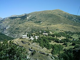 The village of Rabou and the summit of Puy, at 1,834 m (6,017 ft) | |
show Location of Rabou | |
 Rabou | |
| Coordinates: 44°35′30″N 6°00′22″E / 44.5917°N 6.0061°ECoordinates: 44°35′30″N 6°00′22″E / 44.5917°N 6.0061°E | |
| Country | France |
| Region | Provence-Alpes-Côte d'Azur |
| Department | Hautes-Alpes |
| Arrondissement | Gap |
| Canton | Veynes |
| Intercommunality | |
| Government | |
| • Mayor (2020–2026) | Fabien Gascard[1] |
| Area 1 | 26.56 km2 (10.25 sq mi) |
| Population (Jan. 2018)[2] | 83 |
| • Density | 3.1/km2 (8.1/sq mi) |
| Time zone | UTC+01:00 (CET) |
| • Summer (DST) | UTC+02:00 (CEST) |
| INSEE/Postal code | 05112 /05400 |
| Elevation | 1,020–2,280 m (3,350–7,480 ft) (avg. 933 m or 3,061 ft) |
| 1 French Land Register data, which excludes lakes, ponds, glaciers > 1 km2 (0.386 sq mi or 247 acres) and river estuaries. | |


Rabou is a commune in the Hautes-Alpes department in southeastern France.
Population[]
| Year | Pop. | ±% |
|---|---|---|
| 2004 | 78 | — |
| 2006 | 76 | −2.6% |
| 2007 | 77 | +1.3% |
| 2008 | 77 | +0.0% |
| 2009 | 78 | +1.3% |
| 2010 | 79 | +1.3% |
| 2011 | 77 | −2.5% |
| 2012 | 78 | +1.3% |
| 2013 | 78 | +0.0% |
| 2014 | 79 | +1.3% |
| 2015 | 77 | −2.5% |
| 2016 | 76 | −1.3% |
See also[]
- Communes of the Hautes-Alpes department
References[]
- ^ "Répertoire national des élus: les maires". data.gouv.fr, Plateforme ouverte des données publiques françaises (in French). 2 December 2020.
- ^ "Populations légales 2018". INSEE. 28 December 2020.
| Wikimedia Commons has media related to Rabou. |
This Hautes-Alpes geographical article is a stub. You can help Wikipedia by . |
Categories:
- Communes of Hautes-Alpes
- Hautes-Alpes geography stubs