La Saulce
La Saulce | |
|---|---|
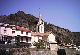 The church and surrounding buildings in La Saulce | |
 Coat of arms | |
show Location of La Saulce | |
 La Saulce | |
| Coordinates: 44°25′34″N 6°00′31″E / 44.4261°N 6.0086°ECoordinates: 44°25′34″N 6°00′31″E / 44.4261°N 6.0086°E | |
| Country | France |
| Region | Provence-Alpes-Côte d'Azur |
| Department | Hautes-Alpes |
| Arrondissement | Gap |
| Canton | Tallard |
| Intercommunality | |
| Government | |
| • Mayor (2020–2026) | Roger Grimaud[1] |
| Area 1 | 7.89 km2 (3.05 sq mi) |
| Population (Jan. 2018)[2] | 1,490 |
| • Density | 190/km2 (490/sq mi) |
| Time zone | UTC+01:00 (CET) |
| • Summer (DST) | UTC+02:00 (CEST) |
| INSEE/Postal code | 05162 /05110 |
| Elevation | 555–1,046 m (1,821–3,432 ft) (avg. 585 m or 1,919 ft) |
| 1 French Land Register data, which excludes lakes, ponds, glaciers > 1 km2 (0.386 sq mi or 247 acres) and river estuaries. | |


La Saulce (French pronunciation: [la sols]; Occitan: La Sauça) is a commune in the Hautes-Alpes department in southeastern France.
Population[]
| Year | Pop. | ±% |
|---|---|---|
| 2005 | 1,168 | — |
| 2006 | 1,190 | +1.9% |
| 2007 | 1,249 | +5.0% |
| 2008 | 1,274 | +2.0% |
| 2009 | 1,288 | +1.1% |
| 2010 | 1,302 | +1.1% |
| 2011 | 1,311 | +0.7% |
| 2012 | 1,319 | +0.6% |
| 2013 | 1,392 | +5.5% |
| 2014 | 1,447 | +4.0% |
| 2015 | 1,502 | +3.8% |
| 2016 | 1,516 | +0.9% |
See also[]
- Communes of the Hautes-Alpes department
References[]
- ^ "Répertoire national des élus: les maires". data.gouv.fr, Plateforme ouverte des données publiques françaises (in French). 2 December 2020.
- ^ "Populations légales 2018". INSEE. 28 December 2020.
| Wikimedia Commons has media related to La Saulce. |
This Hautes-Alpes geographical article is a stub. You can help Wikipedia by . |
Categories:
- Communes of Hautes-Alpes
- Hautes-Alpes geography stubs