Laye, Hautes-Alpes
Laye | |
|---|---|
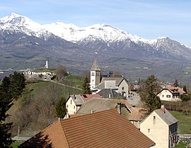 The church and the surrounding buildings in Laye | |
 Coat of arms | |
show Location of Laye | |
 Laye | |
| Coordinates: 44°39′43″N 6°05′06″E / 44.6619°N 6.085°ECoordinates: 44°39′43″N 6°05′06″E / 44.6619°N 6.085°E | |
| Country | France |
| Region | Provence-Alpes-Côte d'Azur |
| Department | Hautes-Alpes |
| Arrondissement | Gap |
| Canton | Saint-Bonnet-en-Champsaur |
| Government | |
| • Mayor (2020–2026) | Anne Marie Antoinette Noulin[1] |
| Area 1 | 10.55 km2 (4.07 sq mi) |
| Population (Jan. 2018)[2] | 239 |
| • Density | 23/km2 (59/sq mi) |
| Time zone | UTC+01:00 (CET) |
| • Summer (DST) | UTC+02:00 (CEST) |
| INSEE/Postal code | 05072 /05500 |
| Elevation | 976–2,158 m (3,202–7,080 ft) (avg. 1,200 m or 3,900 ft) |
| 1 French Land Register data, which excludes lakes, ponds, glaciers > 1 km2 (0.386 sq mi or 247 acres) and river estuaries. | |


Laye is a commune in the Hautes-Alpes department in southeastern France.
Population[]
| Year | Pop. | ±% |
|---|---|---|
| 1962 | 125 | — |
| 1968 | 155 | +24.0% |
| 1975 | 137 | −11.6% |
| 1982 | 163 | +19.0% |
| 1990 | 192 | +17.8% |
| 1999 | 212 | +10.4% |
| 2008 | 231 | +9.0% |

Pic de l'Aiguille
See also[]
- Communes of the Hautes-Alpes department
References[]
- ^ "Répertoire national des élus: les maires". data.gouv.fr, Plateforme ouverte des données publiques françaises (in French). 2 December 2020.
- ^ "Populations légales 2018". INSEE. 28 December 2020.
| Wikimedia Commons has media related to Laye. |
This Hautes-Alpes geographical article is a stub. You can help Wikipedia by . |
Categories:
- Communes of Hautes-Alpes
- Hautes-Alpes geography stubs