Puy-Sanières
Puy-Sanières | |
|---|---|
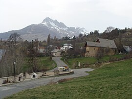 A partial view of the village of Puy-Sanières | |
 Coat of arms | |
show Location of Puy-Sanières | |
 Puy-Sanières | |
| Coordinates: 44°33′32″N 6°26′06″E / 44.5589°N 6.435°ECoordinates: 44°33′32″N 6°26′06″E / 44.5589°N 6.435°E | |
| Country | France |
| Region | Provence-Alpes-Côte d'Azur |
| Department | Hautes-Alpes |
| Arrondissement | Gap |
| Canton | Chorges |
| Government | |
| • Mayor (2020–2026) | Bruno Paris[1] |
| Area 1 | 11.38 km2 (4.39 sq mi) |
| Population (Jan. 2018)[2] | 279 |
| • Density | 25/km2 (63/sq mi) |
| Time zone | UTC+01:00 (CET) |
| • Summer (DST) | UTC+02:00 (CEST) |
| INSEE/Postal code | 05111 /05200 |
| Elevation | 780–2,524 m (2,559–8,281 ft) (avg. 1,125 m or 3,691 ft) |
| 1 French Land Register data, which excludes lakes, ponds, glaciers > 1 km2 (0.386 sq mi or 247 acres) and river estuaries. | |


Puy-Sanières (French pronunciation: [pɥi sanjɛʁ]; Occitan: Puei Sanheras) is a commune in the Hautes-Alpes department in southeastern France.
Population[]
| Year | Pop. | ±% |
|---|---|---|
| 1962 | 42 | — |
| 1968 | 78 | +85.7% |
| 1975 | 66 | −15.4% |
| 1982 | 31 | −53.0% |
| 1990 | 106 | +241.9% |
| 1999 | 155 | +46.2% |
| 2008 | 220 | +41.9% |
See also[]
- Communes of the Hautes-Alpes department
References[]
- ^ "Répertoire national des élus: les maires". data.gouv.fr, Plateforme ouverte des données publiques françaises (in French). 2 December 2020.
- ^ "Populations légales 2018". INSEE. 28 December 2020.
| Wikimedia Commons has media related to Puy-Sanières. |
This Hautes-Alpes geographical article is a stub. You can help Wikipedia by . |
Categories:
- Communes of Hautes-Alpes
- Hautes-Alpes geography stubs