Orcières
Orcières | |
|---|---|
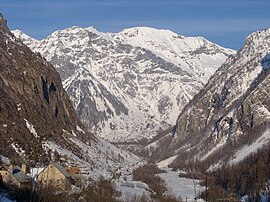 Valley of Prapic | |
 Coat of arms | |
show Location of Orcières | |
 Orcières | |
| Coordinates: 44°41′07″N 6°19′33″E / 44.6853°N 6.3258°ECoordinates: 44°41′07″N 6°19′33″E / 44.6853°N 6.3258°E | |
| Country | France |
| Region | Provence-Alpes-Côte d'Azur |
| Department | Hautes-Alpes |
| Arrondissement | Gap |
| Canton | Saint-Bonnet-en-Champsaur |
| Intercommunality | Champsaur-Valgaudemar |
| Government | |
| • Mayor (2020–2026) | Patrick Ricou |
| Area 1 | 98.27 km2 (37.94 sq mi) |
| Population (Jan. 2018)[1] | 670 |
| • Density | 6.8/km2 (18/sq mi) |
| Time zone | UTC+01:00 (CET) |
| • Summer (DST) | UTC+02:00 (CEST) |
| INSEE/Postal code | 05096 /05170 |
| Elevation | 1,174–3,117 m (3,852–10,226 ft) (avg. 1,439 m or 4,721 ft) |
| 1 French Land Register data, which excludes lakes, ponds, glaciers > 1 km2 (0.386 sq mi or 247 acres) and river estuaries. | |


Orcières (French pronunciation: [ɔʁsjɛʁ]) is a commune in the Hautes-Alpes department in southeastern France.
Population[]
| Year | Pop. | ±% |
|---|---|---|
| 1962 | 514 | — |
| 1968 | 734 | +42.8% |
| 1975 | 855 | +16.5% |
| 1982 | 890 | +4.1% |
| 1990 | 841 | −5.5% |
| 1999 | 810 | −3.7% |
| 2008 | 700 | −13.6% |
See also[]
- Communes of the Hautes-Alpes department
References[]
- ^ "Populations légales 2018". INSEE. 28 December 2020.
| Wikimedia Commons has media related to Orcières. |
This Hautes-Alpes geographical article is a stub. You can help Wikipedia by . |
Categories:
- Communes of Hautes-Alpes
- Hautes-Alpes geography stubs