Vallouise-Pelvoux
Vallouise-Pelvoux | |
|---|---|
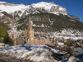 A view of Vallouise in winter | |
Location of Vallouise-Pelvoux  | |
 Vallouise-Pelvoux | |
| Coordinates: 44°51′54″N 6°29′20″E / 44.865°N 6.489°ECoordinates: 44°51′54″N 6°29′20″E / 44.865°N 6.489°E | |
| Country | France |
| Region | Provence-Alpes-Côte d'Azur |
| Department | Hautes-Alpes |
| Arrondissement | Briançon |
| Canton | L'Argentière-la-Bessée |
| Intercommunality | Pays des Écrins |
| Area 1 | 144.81 km2 (55.91 sq mi) |
| Population (Jan. 2018)[1] | 1,178 |
| • Density | 8.1/km2 (21/sq mi) |
| Time zone | UTC+01:00 (CET) |
| • Summer (DST) | UTC+02:00 (CEST) |
| INSEE/Postal code | 05101 /05290, 05340 |
| 1 French Land Register data, which excludes lakes, ponds, glaciers > 1 km2 (0.386 sq mi or 247 acres) and river estuaries. | |


Vallouise-Pelvoux is a commune in the department of Hautes-Alpes, southeastern France. The municipality was established on 1 January 2017 by merger of the former communes of Pelvoux (the seat) and Vallouise.[2]
The commune is located in the Alps and contains part of the Écrins National Park.
It is a popular destination for mountaineering and mountain sports in all seasons.
See also[]
- Communes of the Hautes-Alpes department
References[]
| Wikimedia Commons has media related to Vallouise-Pelvoux. |
- ^ "Populations légales 2018". The National Institute of Statistics and Economic Studies. 28 December 2020.
- ^ Arrêté préfectoral 5 September 2016 (in French)
This Hautes-Alpes geographical article is a stub. You can help Wikipedia by . |
Categories:
- Communes of Hautes-Alpes
- Hautes-Alpes geography stubs