Tallard
show This article may be expanded with text translated from the corresponding article in French. (July 2014) Click [show] for important translation instructions. |
Tallard | |
|---|---|
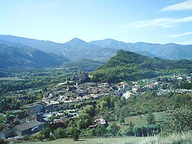 The village of Tallard | |
 Coat of arms | |
show Location of Tallard | |
 Tallard | |
| Coordinates: 44°27′45″N 6°03′19″E / 44.4625°N 6.0553°ECoordinates: 44°27′45″N 6°03′19″E / 44.4625°N 6.0553°E | |
| Country | France |
| Region | Provence-Alpes-Côte d'Azur |
| Department | Hautes-Alpes |
| Arrondissement | Gap |
| Canton | Tallard |
| Government | |
| • Mayor (2020–2026) | Daniel Borel |
| Area 1 | 15.02 km2 (5.80 sq mi) |
| Population (Jan. 2018)[1] | 2,246 |
| • Density | 150/km2 (390/sq mi) |
| Time zone | UTC+01:00 (CET) |
| • Summer (DST) | UTC+02:00 (CEST) |
| INSEE/Postal code | 05170 /05130 |
| Elevation | 570–1,121 m (1,870–3,678 ft) (avg. 604 m or 1,982 ft) |
| 1 French Land Register data, which excludes lakes, ponds, glaciers > 1 km2 (0.386 sq mi or 247 acres) and river estuaries. | |


Tallard (French pronunciation: [talaʁ]; Occitan: Talard) is a commune in the Hautes-Alpes department in the Provence-Alpes-Côte d'Azur region in southeastern France.
Location[]
Tallard is 20 km (12 mi) to the south of Gap, close to the road from Gap to Marseille. The motorway A51 ends just to the south, near the village of La Saulce. The village is 21 km (13 mi) away from La Bâtie-Vieille and is also home to the Internationally renowned Gap-Tallard Aerodrome, home of CERPS Skydiving Club and French military parachute training.
Mayor[]
Jean-Michel Arnaud (UDF) was mayor of Tallard from 2001 to 2020. Daniel Borel was elected mayor in November 2020.
Population[]
| Year | Pop. | ±% |
|---|---|---|
| 1962 | 935 | — |
| 1968 | 1,063 | +13.7% |
| 1975 | 1,092 | +2.7% |
| 1982 | 1,155 | +5.8% |
| 1990 | 1,187 | +2.8% |
| 1999 | 1,298 | +9.4% |
| 2008 | 1,909 | +47.1% |
| 2017 | 2,206 | +15.6% |
Inhabitants are called Tallardiens.
Tour de France[]
In 2007, Tallard was the start for the 229.5 km (142.6 mi) stage 10 of the Tour de France to Marseille.
See also[]
- Communes of the Hautes-Alpes department
References[]
- ^ "Populations légales 2018". INSEE. 28 December 2020.
External links[]
| Wikimedia Commons has media related to Tallard. |
| show Authority control |
|---|
This Hautes-Alpes geographical article is a stub. You can help Wikipedia by . |
- Communes of Hautes-Alpes
- Hautes-Alpes geography stubs