Guillestre
show This article may be expanded with text translated from the corresponding article in French. (July 2014) Click [show] for important translation instructions. |
Guillestre | |
|---|---|
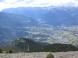 A panoramic view of Guillestre to the right, and the village of Risoul, left | |
 Coat of arms | |
show Location of Guillestre | |
 Guillestre | |
| Coordinates: 44°40′N 6°39′E / 44.66°N 6.65°ECoordinates: 44°40′N 6°39′E / 44.66°N 6.65°E | |
| Country | France |
| Region | Provence-Alpes-Côte d'Azur |
| Department | Hautes-Alpes |
| Arrondissement | Briançon |
| Canton | Guillestre |
| Government | |
| • Mayor (2020–2026) | Christine Portevin[1] |
| Area 1 | 51.29 km2 (19.80 sq mi) |
| Population (Jan. 2018)[2] | 2,334 |
| • Density | 46/km2 (120/sq mi) |
| Time zone | UTC+01:00 (CET) |
| • Summer (DST) | UTC+02:00 (CEST) |
| INSEE/Postal code | 05065 /05600 |
| Elevation | 867–2,694 m (2,844–8,839 ft) (avg. 1,050 m or 3,440 ft) |
| 1 French Land Register data, which excludes lakes, ponds, glaciers > 1 km2 (0.386 sq mi or 247 acres) and river estuaries. | |


Guillestre (French pronunciation: [ɡijɛstʁ]; Vivaro-Alpine: Guilhèstra) is a commune in the Hautes-Alpes department in southeastern France.
Geography[]
The village lies in the northwestern part of the commune, on the left bank of the Chagne, a stream, tributary of the Guil, which forms all of the commune's northern border, before flowing into the Durance, which forms part of the commune's western border. The village also lies high within the alps of France.
Population[]
| Year | Pop. | ±% |
|---|---|---|
| 1962 | 1,448 | — |
| 1968 | 1,479 | +2.1% |
| 1975 | 1,466 | −0.9% |
| 1982 | 1,937 | +32.1% |
| 1990 | 2,000 | +3.3% |
| 1999 | 2,211 | +10.5% |
| 2008 | 2,290 | +3.6% |
| 2012 | 2,367 | +3.4% |
See also[]
- Communes of the Hautes-Alpes department
References[]
- ^ Christine Portevin elue nouvelle maire de Guillestre, dici.fr, 24 May 2020
- ^ "Populations légales 2018". INSEE. 28 December 2020.
| Wikimedia Commons has media related to Guillestre. |
| show Authority control |
|---|
This Hautes-Alpes geographical article is a stub. You can help Wikipedia by . |
Categories:
- Communes of Hautes-Alpes
- Hautes-Alpes geography stubs