Saint-Léger-les-Mélèzes
Saint-Léger-les-Mélèzes | |
|---|---|
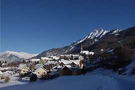 A view of Saint-Léger-les-Mélèzes in winter | |
 Coat of arms | |
show Location of Saint-Léger-les-Mélèzes | |
 Saint-Léger-les-Mélèzes | |
| Coordinates: 44°38′40″N 6°11′56″E / 44.6444°N 6.1989°ECoordinates: 44°38′40″N 6°11′56″E / 44.6444°N 6.1989°E | |
| Country | France |
| Region | Provence-Alpes-Côte d'Azur |
| Department | Hautes-Alpes |
| Arrondissement | Gap |
| Canton | Saint-Bonnet-en-Champsaur |
| Government | |
| • Mayor (2020–2026) | Gérald Martinez[1] |
| Area 1 | 6.76 km2 (2.61 sq mi) |
| Population (Jan. 2018)[2] | 356 |
| • Density | 53/km2 (140/sq mi) |
| Time zone | UTC+01:00 (CET) |
| • Summer (DST) | UTC+02:00 (CEST) |
| INSEE/Postal code | 05149 /05260 |
| Elevation | 1,076–2,459 m (3,530–8,068 ft) (avg. 1,263 m or 4,144 ft) |
| 1 French Land Register data, which excludes lakes, ponds, glaciers > 1 km2 (0.386 sq mi or 247 acres) and river estuaries. | |


Saint-Léger-les-Mélèzes (French pronunciation: [sɛ̃ leʒe le melɛz]; Vivaro-Alpine: Sant Lagier) is a commune in the Hautes-Alpes department in southeastern France.
Population[]
| Year | Pop. | ±% |
|---|---|---|
| 1962 | 115 | — |
| 1968 | 137 | +19.1% |
| 1975 | 224 | +63.5% |
| 1982 | 190 | −15.2% |
| 1990 | 182 | −4.2% |
| 1999 | 228 | +25.3% |
| 2008 | 318 | +39.5% |
See also[]
- Communes of the Hautes-Alpes department
References[]
- ^ "Répertoire national des élus: les maires". data.gouv.fr, Plateforme ouverte des données publiques françaises (in French). 2 December 2020. Retrieved 7 December 2020.
- ^ "Populations légales 2018". INSEE. 28 December 2020.
| Wikimedia Commons has media related to Saint-Léger-les-Mélèzes. |
This Hautes-Alpes geographical article is a stub. You can help Wikipedia by . |
Categories:
- Communes of Hautes-Alpes
- Hautes-Alpes geography stubs