Le Glaizil
Le Glaizil | |
|---|---|
 Ruins of the Castle of Lesdiguières | |
 Coat of arms | |
show Location of Le Glaizil | |
 Le Glaizil | |
| Coordinates: 44°45′16″N 5°59′00″E / 44.7544°N 5.9833°ECoordinates: 44°45′16″N 5°59′00″E / 44.7544°N 5.9833°E | |
| Country | France |
| Region | Provence-Alpes-Côte d'Azur |
| Department | Hautes-Alpes |
| Arrondissement | Gap |
| Canton | Saint-Bonnet-en-Champsaur |
| Government | |
| • Mayor (2020–2026) | François Collin[1] |
| Area 1 | 21.93 km2 (8.47 sq mi) |
| Population (Jan. 2018)[2] | 163 |
| • Density | 7.4/km2 (19/sq mi) |
| Time zone | UTC+01:00 (CET) |
| • Summer (DST) | UTC+02:00 (CEST) |
| INSEE/Postal code | 05062 /05800 |
| Elevation | 774–2,570 m (2,539–8,432 ft) (avg. 862 m or 2,828 ft) |
| 1 French Land Register data, which excludes lakes, ponds, glaciers > 1 km2 (0.386 sq mi or 247 acres) and river estuaries. | |


Le Glaizil (French pronunciation: [lə ɡlɛzil]; Occitan: Lo Glaisiu) is a commune in the Hautes-Alpes department in southeastern France. It is famous for hosting the ruins of the castle of the Duke of Lesdiguières, Constable of France in the 17th century.
Population[]
| Year | Pop. | ±% |
|---|---|---|
| 1962 | 115 | — |
| 1968 | 155 | +34.8% |
| 1975 | 168 | +8.4% |
| 1982 | 175 | +4.2% |
| 1990 | 169 | −3.4% |
| 1999 | 179 | +5.9% |
| 2008 | 170 | −5.0% |
| 2012 | 180 | +5.9% |
Gallery[]
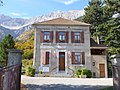
The Town Hall
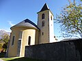
The Church

The War Memorial

The Cemetery Cross (1771)

A Cross (1889)

Ruins of the Castle of Lesdiguières

The Chapel of the Castle of Lesdiguières


See also[]
- Communes of the Hautes-Alpes department
References[]
- ^ "Répertoire national des élus: les maires". data.gouv.fr, Plateforme ouverte des données publiques françaises (in French). 2 December 2020.
- ^ "Populations légales 2018". INSEE. 28 December 2020.
| Wikimedia Commons has media related to Le Glaizil. |
This Hautes-Alpes geographical article is a stub. You can help Wikipedia by . |
Categories:
- Communes of Hautes-Alpes
- Hautes-Alpes geography stubs