Courtes
show This article may be expanded with text translated from the corresponding article in French. (December 2008) Click [show] for important translation instructions. |
Courtes | |
|---|---|
Commune | |
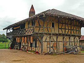 Museum La Ferme de la forêt | |
show Location of Courtes | |
 Courtes | |
| Coordinates: 46°27′36″N 5°06′03″E / 46.46°N 5.1008°ECoordinates: 46°27′36″N 5°06′03″E / 46.46°N 5.1008°E | |
| Country | France |
| Region | Auvergne-Rhône-Alpes |
| Department | Ain |
| Arrondissement | Bourg-en-Bresse |
| Canton | Replonges |
| Intercommunality | CA Bassin de Bourg-en-Bresse |
| Government | |
| • Mayor (2020–2026) | Thierry Pallegoix[1] |
| Area 1 | 9.06 km2 (3.50 sq mi) |
| Population (Jan. 2018)[2] | 309 |
| • Density | 34/km2 (88/sq mi) |
| Time zone | UTC+01:00 (CET) |
| • Summer (DST) | UTC+02:00 (CEST) |
| INSEE/Postal code | 01128 /01560 |
| Elevation | 192–221 m (630–725 ft) (avg. 212 m or 696 ft) |
| 1 French Land Register data, which excludes lakes, ponds, glaciers > 1 km2 (0.386 sq mi or 247 acres) and river estuaries. | |


Courtes is a commune in the Ain department in eastern France.
Geography[]
The Sâne Vive forms part of the commune's eastern border.
Population[]
|
|
See also[]
References[]
- ^ "Répertoire national des élus: les maires". data.gouv.fr, Plateforme ouverte des données publiques françaises (in French). 2 December 2020.
- ^ "Populations légales 2018". INSEE. 28 December 2020.
| Wikimedia Commons has media related to Courtes. |
This Ain geographical article is a stub. You can help Wikipedia by . |
Categories:
- Communes of Ain
- Ain geography stubs