Sournia
Sournia
Sornià Sornhan | |
|---|---|
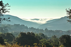 A general view of Sournia | |
 Coat of arms | |
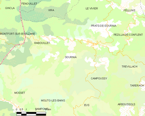
show Location of Sournia | |
 Sournia | |
| Coordinates: 42°43′43″N 2°26′34″E / 42.7286°N 2.4428°ECoordinates: 42°43′43″N 2°26′34″E / 42.7286°N 2.4428°E | |
| Country | France |
| Region | Occitanie |
| Department | Pyrénées-Orientales |
| Arrondissement | Prades |
| Canton | La Vallée de l'Agly |
| Government | |
| • Mayor (2020–2026) | Yvon Crambes |
| Area 1 | 29.99 km2 (11.58 sq mi) |
| Population (Jan. 2018)[1] | 497 |
| • Density | 17/km2 (43/sq mi) |
| Time zone | UTC+01:00 (CET) |
| • Summer (DST) | UTC+02:00 (CEST) |
| INSEE/Postal code | 66198 /66730 |
| Elevation | 380–1,234 m (1,247–4,049 ft) (avg. 500 m or 1,600 ft) |
| 1 French Land Register data, which excludes lakes, ponds, glaciers > 1 km2 (0.386 sq mi or 247 acres) and river estuaries. | |


Sournia (French pronunciation: [suʁnja] (![]() listen); Catalan: Sornià; Occitan: Sornhan) is a commune in the Pyrénées-Orientales department in the Occitanie region of south-western France. Its inhabitants are known as Sourniannais.
listen); Catalan: Sornià; Occitan: Sornhan) is a commune in the Pyrénées-Orientales department in the Occitanie region of south-western France. Its inhabitants are known as Sourniannais.
Geography[]
Sournia is a town of the Fenouillèdes, the languedocienne part of the Pyrénées-Orientales, in the canton of La Vallée de l'Agly and in the arrondissement of Prades. The river Désix runs through the village. Sournia is 22 km from Ille-sur-Têt and from Vinça, 24 km from Prades and from Saint-Paul-de-Fenouillet, 30 km from Latour-de-France and 34 km from Axat.
The commune is covered by the quality wine standard AOC 'Côtes-du-Roussillon'.
Sournia is crossed by the long distance footpath, GR 36.
Administration[]
The current mayor of Sournia is Paul Blanc, a senator, of the centre-right and right wing party UMP founded by Jacques Chirac.
Population[]
The population of Sournia in 2017 was 498 people. For some reason at the end of the 19th century, the population of Sournia seemed to have a reputation for having one of the longest longevity in France, even though this fact was not clearly verified.[2]
|
| ||||||||||||||||||||||||||||||||||||||||||||||||||||||||||||||||||||||||||||||||||||||||||||||||||||||||||||||||||
| Source: EHESS[3] and INSEE (1968-2017)[4] | |||||||||||||||||||||||||||||||||||||||||||||||||||||||||||||||||||||||||||||||||||||||||||||||||||||||||||||||||||
Places of interest[]
- Ruins of the former church of Saint-Michel from the tenth century.
- The ancient church of Sainte-Félicité from the tenth and eleventh centuries.
- Church of Arsa from the twelfth century.
See also[]
References[]
- ^ "Populations légales 2018". INSEE. 28 December 2020.
- ^ (in French) Fabricio Cardenas, Vieux papiers des Pyrénées-Orientales, Record de longévité à Sournia en 1897 , 3 January 2015
- ^ Des villages de Cassini aux communes d'aujourd'hui: Commune data sheet Sournia, EHESS. (in French)
- ^ Population en historique depuis 1968, INSEE
| Wikimedia Commons has media related to Sournia. |
| show Authority control |
|---|
This Pyrénées-Orientales geographical article is a stub. You can help Wikipedia by . |
- Communes of Pyrénées-Orientales
- Fenouillèdes
- Pyrénées-Orientales geography stubs