Le Pertre
Le Pertre
Ar Perzh | |
|---|---|
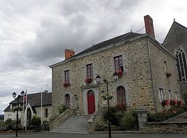 The town hall of Le Pertre | |
 Coat of arms | |
show Location of Le Pertre | |
 Le Pertre | |
| Coordinates: 48°02′08″N 1°02′09″W / 48.0356°N 1.0358°WCoordinates: 48°02′08″N 1°02′09″W / 48.0356°N 1.0358°W | |
| Country | France |
| Region | Brittany |
| Department | Ille-et-Vilaine |
| Arrondissement | Fougères-Vitré |
| Canton | La Guerche-de-Bretagne |
| Intercommunality | CA Vitré Communauté |
| Government | |
| • Mayor (2020–2026) | Jean-Luc Veillé |
| Area 1 | 43.63 km2 (16.85 sq mi) |
| Population (Jan. 2018)[1] | 1,385 |
| • Density | 32/km2 (82/sq mi) |
| Time zone | UTC+01:00 (CET) |
| • Summer (DST) | UTC+02:00 (CEST) |
| INSEE/Postal code | 35217 /35370 |
| Elevation | 67–184 m (220–604 ft) |
| 1 French Land Register data, which excludes lakes, ponds, glaciers > 1 km2 (0.386 sq mi or 247 acres) and river estuaries. | |


Le Pertre (French pronunciation: [lə pɛʁtʁ];Breton: Ar Perzh) is a commune in the Ille-et-Vilaine department of Brittany in northwestern France.
Heritage[]
The church of Saint-Martin-de-Vertou is located in the centre of the village. The steeple of the church was originally constructed to a height of 83 metres in 1920. However due to repairs, especially after the fall of the steeple of 1982, the height may have changed. It is possible to access a parapet located at 37 metres from the ground. Legend has it that thirty-nine bell towers are visible in good weather from the top of the church.
Le Pertre forest has an area of 1,513 hectares. It is an oak grove which was classified, in 1997, as a natural area of ecological interest, faunistic and floristic. It has some ornithological interest since thirty-two species of birds are listed there, five of which are uncommon in the region (Honey Buzzard, Common Hawk, Hoopoe, Redstart, and Woodpecker). In addition, this forest has two species of bats.
Population[]
Inhabitants of Le Pertre are called in French pertrais.
| Year | Pop. | ±% |
|---|---|---|
| 1791 | 2,200 | — |
| 1911 | 1,911 | −13.1% |
| 1921 | 1,508 | −21.1% |
| 1962 | 1,277 | −15.3% |
| 1968 | 1,376 | +7.8% |
| 1975 | 1,270 | −7.7% |
| 1982 | 1,335 | +5.1% |
| 1990 | 1,326 | −0.7% |
| 1999 | 1,361 | +2.6% |
| 2008 | 1,434 | +5.4% |
See also[]
- Communes of the Ille-et-Vilaine department
References[]
- ^ "Populations légales 2018". INSEE. 28 December 2020.
External links[]
| Wikimedia Commons has media related to Le Pertre. |
- Official website Le Pertre (in French)
- Base Mérimée: Search for heritage in the commune, Ministère français de la Culture. (in French)
- Mayors of Ille-et-Vilaine Association (in French)
| show Communes of the Ille-et-Vilaine department |
|---|
This Ille-et-Vilaine geographical article is a stub. You can help Wikipedia by . |
- Communes of Ille-et-Vilaine
- Ille-et-Vilaine geography stubs