Pozières
Pozières | |
|---|---|
 The tank monument in Pozières | |
show Location of Pozières | |
 Pozières | |
| Coordinates: 50°02′24″N 02°43′30″E / 50.04000°N 2.72500°ECoordinates: 50°02′24″N 02°43′30″E / 50.04000°N 2.72500°E | |
| Country | France |
| Region | Hauts-de-France |
| Department | Somme |
| Arrondissement | Péronne |
| Canton | Albert |
| Intercommunality | Pays du Coquelicot |
| Government | |
| • Mayor (2020–2026) | Dominique Bierwald[1] |
| Area 1 | 3.24 km2 (1.25 sq mi) |
| Population (Jan. 2018)[2] | 267 |
| • Density | 82/km2 (210/sq mi) |
| Time zone | UTC+01:00 (CET) |
| • Summer (DST) | UTC+02:00 (CEST) |
| INSEE/Postal code | 80640 /80300 |
| Elevation | 115–161 m (377–528 ft) (avg. 163 m or 535 ft) |
| 1 French Land Register data, which excludes lakes, ponds, glaciers > 1 km2 (0.386 sq mi or 247 acres) and river estuaries. | |


Pozières ([pɔz.jɛːʁ]; Picard: Pozière) is a commune in the Somme department in Hauts-de-France in northern France.
Geography[]
The commune is situated on the D929 road, 34 kilometres (21 mi) northeast of Amiens between Albert and Bapaume, on the Pozières ridge.
Southwest of the village on Departmental Road 929 is the Pozières Memorial and Pozieres British Cemetery. The cemetery. A total of 14,720 men, mostly Australians, are buried here. Unidentified dead number 1,380. The memorial was dedicated in August 1930.[3]
Population[]
| Year | Pop. | ±% p.a. |
|---|---|---|
| 1968 | 281 | — |
| 1975 | 254 | −1.43% |
| 1982 | 279 | +1.35% |
| 1990 | 276 | −0.14% |
| 1999 | 244 | −1.36% |
| 2007 | 236 | −0.42% |
| 2012 | 255 | +1.56% |
| 2017 | 266 | +0.85% |
| Source: INSEE[4] | ||
History[]
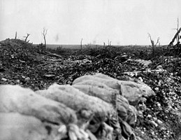
The village was completely destroyed in World War I during what became the Battle of Pozières (23 July–7 August 1916), which was part of the Battle of the Somme. The village was subsequently rebuilt, and is now the site of several war memorials. The Australian flag flies over Pozières in recognition of the sacrifice of the ANZACs in the Battle of Pozières.[citation needed] Amongst the British and other Commonwealth forces who fought at Pozières, the Australians suffered over 5,000 killed, wounded or taken prisoner.
One of those killed, on 5 August, was the English composer George Butterworth, and in 2008[citation needed] the road between the town and Martinpuich was renamed Chemin George Butterworth (George Butterworth Lane); 50°02′28″N 2°43′59″E / 50.041172°N 2.733112°E).[5]
Gallery[]

A fatigue party from the Australian 7th Brigade (Australian 2nd Division) pass the former German bunker known as "Gibraltar" at the western end of Pozières, 28 August 1916, during the Battle of the Somme. The infantry are laden with empty sandbags, heading towards the fighting around Mouquet Farm, north of Pozières.
The view from Centre Way trench towards Mouquet Farm, August 1916

Map showing Mouquet Farm and the German defensive fortifications from Thiepval to Courcelette, July 1916
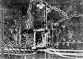
Mouquet Farm and its defences, June 1916[a]

Mouquet Farm and its defences, September 1916[b]


See also[]
Notes[]
- ^ Ruins of farmhouse buildings are rectangular area at lower centre. Trench across top right is the western end of Fabeck Graben Trench at top left heading NNW is Zollern Redoubt. From lower centre a road not extant runs ENE to Courcelette; road at bottom heads SE towards Pozières; road running WSW at bottom left connects with Thiepval–Pozières road. The attacks were made from south to north, British on left and Australians centre and right
- ^ The farm building area is open land now and the rebuilt farm buildings are south of the road
References[]
- ^ "Répertoire national des élus: les maires". data.gouv.fr, Plateforme ouverte des données publiques françaises (in French). 2 December 2020.
- ^ "Populations légales 2018". INSEE. 28 December 2020.
- ^ "Pozieres Memorial". Commonwealth War Graves Commission. Retrieved 11 February 2021.
- ^ Population en historique depuis 1968, INSEE
- ^ "Le chemin George Sainton Kaye Butterworth Lane". Images-en-somme.fr. Retrieved 2011-10-15.
External links[]
| Wikimedia Commons has media related to Pozières. |
| show Authority control |
|---|
This World War I article is a stub. You can help Wikipedia by . |
- Communes of Somme (department)
- World War I sites in France
- Péronne arrondissement geography stubs
- World War I stubs