Vrély
From Wikipedia, the free encyclopedia
Commune in Hauts-de-France, France
Vrély | |
|---|---|
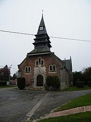 The church in Vrély | |
Location of Vrély  | |
 Vrély  Vrély | |
Coordinates:  49°47′56″N 2°41′38″E / 49.7989°N 2.6939°E / 49.7989; 2.6939Coordinates: 49°47′56″N 2°41′38″E / 49.7989°N 2.6939°E / 49.7989; 2.6939 49°47′56″N 2°41′38″E / 49.7989°N 2.6939°E / 49.7989; 2.6939Coordinates: 49°47′56″N 2°41′38″E / 49.7989°N 2.6939°E / 49.7989; 2.6939 | |
| Country | France |
| Region | Hauts-de-France |
| Department | Somme |
| Arrondissement | Péronne |
| Canton | Moreuil |
| Intercommunality | Terre de Picardie |
| Government | |
| • Mayor (2020–2026) | Jean-Marie Adde |
| Area 1 | 5.66 km2 (2.19 sq mi) |
| Population (Jan. 2018)[1] | 443 |
| • Density | 78/km2 (200/sq mi) |
| Time zone | UTC+01:00 (CET) |
| • Summer (DST) | UTC+02:00 (CEST) |
| INSEE/Postal code | 80814 /80170 |
| Elevation | 68–97 m (223–318 ft) (avg. 95 m or 312 ft) |
| 1 French Land Register data, which excludes lakes, ponds, glaciers > 1 km2 (0.386 sq mi or 247 acres) and river estuaries. | |
Vrély is a commune in the Somme department in Hauts-de-France in northern France.
Contents
Geography[]
The commune is situated 25 miles (40 km) southwest of Amiens, at the junction of the D34 and D329 roads.
Population[]
| Year | Pop. | ±% p.a. |
|---|---|---|
| 1968 | 486 | — |
| 1975 | 423 | −1.96% |
| 1982 | 415 | −0.27% |
| 1990 | 406 | −0.27% |
| 1999 | 431 | +0.67% |
| 2007 | 458 | +0.76% |
| 2012 | 454 | −0.18% |
| 2017 | 437 | −0.76% |
| Source: INSEE[2] | ||
See also[]
References[]
- ^ "Populations légales 2018". The National Institute of Statistics and Economic Studies. 28 December 2020.
- ^ Population en historique depuis 1968, INSEE
| Wikimedia Commons has media related to Vrély. |
Communes of the Somme department | |
|---|---|
|
This Arrondissement of Péronne geographical article is a stub. You can help Wikipedia by . |
Retrieved from ""
Categories:
- Communes of Somme (department)
- Péronne arrondissement geography stubs
Hidden categories:
- Articles with short description
- Short description is different from Wikidata
- Infobox mapframe without OSM relation ID on Wikidata
- Coordinates on Wikidata
- Pages using infobox settlement with image map1 but not image map
- Commons category link from Wikidata
- AC with 0 elements
- All stub articles
- Pages using the Kartographer extension