Vraignes-en-Vermandois
From Wikipedia, the free encyclopedia
Commune in Hauts-de-France, France
Vraignes-en-Vermandois | |
|---|---|
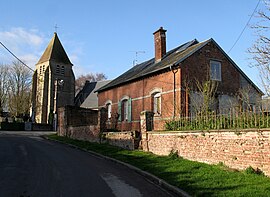 The church in Vraignes-en-Vermandois | |
 Vraignes-en-Vermandois  Vraignes-en-Vermandois | |
| Coordinates: 49°53′16″N 3°03′58″E / 49.8878°N 3.0661°E / 49.8878; 3.0661Coordinates: 49°53′16″N 3°03′58″E / 49.8878°N 3.0661°E / 49.8878; 3.0661 | |
| Country | France |
| Region | Hauts-de-France |
| Department | Somme |
| Arrondissement | Péronne |
| Canton | Péronne |
| Intercommunality | Haute Somme |
| Government | |
| • Mayor (2020–2026) | Maryse Fagot |
| Area 1 | 4.22 km2 (1.63 sq mi) |
| Population (Jan. 2018)[1] | 139 |
| • Density | 33/km2 (85/sq mi) |
| Time zone | UTC+01:00 (CET) |
| • Summer (DST) | UTC+02:00 (CEST) |
| INSEE/Postal code | 80812 /80240 |
| Elevation | 67–103 m (220–338 ft) (avg. 93 m or 305 ft) |
| 1 French Land Register data, which excludes lakes, ponds, glaciers > 1 km2 (0.386 sq mi or 247 acres) and river estuaries. | |

Vraignes-en-Vermandois is a commune in the Somme department in Hauts-de-France in northern France.
Contents
Geography[]
The commune is situated 12 miles (19 km) northwest of Saint-Quentin, on the D15 road and on the border with the department of Aisne.
Population[]
| Year | 1962 | 1968 | 1975 | 1982 | 1990 | 1999 | 2006 | 2011 | 2015 |
|---|---|---|---|---|---|---|---|---|---|
| Population | 116 | 154 | 146 | 150 | 145 | 148 | 162 | 162 | 148 |
| From the year 1962 on: No double counting—residents of multiple communes (e.g. students and military personnel) are counted only once. | |||||||||
See also[]
References[]
- ^ "Populations légales 2018". INSEE. 28 December 2020.
| Wikimedia Commons has media related to Vraignes-en-Vermandois. |
show
Communes of the Somme department | |
|---|---|
|
This Arrondissement of Péronne geographical article is a stub. You can help Wikipedia by . |
Retrieved from ""
Categories:
- Communes of Somme (department)
- Péronne arrondissement geography stubs
Hidden categories:
- Articles with short description
- Short description is different from Wikidata
- Infobox mapframe without OSM relation ID on Wikidata
- Coordinates on Wikidata
- Pages using infobox settlement with image map1 but not image map
- Commons category link from Wikidata
- Articles with BNF identifiers
- All stub articles
- Pages using the Kartographer extension