Mouflières
From Wikipedia, the free encyclopedia
Commune in Hauts-de-France, France
Mouflières | |
|---|---|
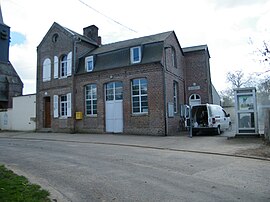 The town hall in Mouflières | |
 Mouflières  Mouflières | |
Coordinates:  49°55′22″N 1°44′35″E / 49.9228°N 1.7431°E / 49.9228; 1.7431Coordinates: 49°55′22″N 1°44′35″E / 49.9228°N 1.7431°E / 49.9228; 1.7431 49°55′22″N 1°44′35″E / 49.9228°N 1.7431°E / 49.9228; 1.7431Coordinates: 49°55′22″N 1°44′35″E / 49.9228°N 1.7431°E / 49.9228; 1.7431 | |
| Country | France |
| Region | Hauts-de-France |
| Department | Somme |
| Arrondissement | Amiens |
| Canton | Poix-de-Picardie |
| Intercommunality | CC Somme Sud-Ouest |
| Government | |
| • Mayor (2020–2026) | Claude Morel[1] |
| Area 1 | 2.76 km2 (1.07 sq mi) |
| Population (Jan. 2018)[2] | 83 |
| • Density | 30/km2 (78/sq mi) |
| Time zone | UTC+01:00 (CET) |
| • Summer (DST) | UTC+02:00 (CEST) |
| INSEE/Postal code | 80575 /80140 |
| Elevation | 114–152 m (374–499 ft) (avg. 150 m or 490 ft) |
| 1 French Land Register data, which excludes lakes, ponds, glaciers > 1 km2 (0.386 sq mi or 247 acres) and river estuaries. | |

Mouflières is a commune in the Somme department in Hauts-de-France in northern France.
Contents
Geography[]
The commune is situated on the D25 road, some 15 miles (24 km) south of Abbeville.
Population[]
| Year | Pop. | ±% p.a. |
|---|---|---|
| 1968 | 90 | — |
| 1975 | 96 | +0.93% |
| 1982 | 86 | −1.56% |
| 1990 | 74 | −1.86% |
| 1999 | 71 | −0.46% |
| 2007 | 89 | +2.86% |
| 2012 | 96 | +1.53% |
| 2017 | 86 | −2.18% |
| Source: INSEE[3] | ||
See also[]
References[]
- ^ "Répertoire national des élus: les maires". data.gouv.fr, Plateforme ouverte des données publiques françaises (in French). 2 December 2020.
- ^ "Populations légales 2018". INSEE. 28 December 2020.
- ^ Population en historique depuis 1968, INSEE
| Wikimedia Commons has media related to Mouflières. |
show
Communes of the Somme department | |
|---|---|
|
This Arrondissement of Amiens geographical article is a stub. You can help Wikipedia by . |
- v
- t
Retrieved from ""
Categories:
- Communes of Somme (department)
- Amiens arrondissement geography stubs
Hidden categories:
- CS1 French-language sources (fr)
- Articles with short description
- Short description is different from Wikidata
- Infobox mapframe without OSM relation ID on Wikidata
- Coordinates on Wikidata
- Pages using infobox settlement with image map1 but not image map
- Commons category link from Wikidata
- Articles with BNF identifiers
- All stub articles
- Pages using the Kartographer extension