Épécamps
Épécamps | |
|---|---|
 Town hall. | |
Location of Épécamps  | |
 Épécamps | |
| Coordinates: 50°06′48″N 2°09′21″E / 50.1133°N 2.1558°ECoordinates: 50°06′48″N 2°09′21″E / 50.1133°N 2.1558°E | |
| Country | France |
| Region | Hauts-de-France |
| Department | Somme |
| Arrondissement | Amiens |
| Canton | Doullens |
| Intercommunality | Territoire Nord Picardie |
| Government | |
| • Mayor (2021–2026) | Emilie Deramecourt[1] |
| Area 1 | 1.6 km2 (0.6 sq mi) |
| Population (Jan. 2018)[2] | 5 |
| • Density | 3.1/km2 (8.1/sq mi) |
| Time zone | UTC+01:00 (CET) |
| • Summer (DST) | UTC+02:00 (CEST) |
| INSEE/Postal code | 80270 /80370 |
| Elevation | 75–146 m (246–479 ft) (avg. 136 m or 446 ft) |
| 1 French Land Register data, which excludes lakes, ponds, glaciers > 1 km2 (0.386 sq mi or 247 acres) and river estuaries. | |

Épécamps is a commune in the Somme department in Hauts-de-France in northern France.
Geography[]
The least populous commune in the department, Épécamps is situated on the D118 road, some 28 km (17 mi) east of Abbeville.
Population[]
| Year | Pop. | ±% |
|---|---|---|
| 2006 | 8 | — |
| 2007 | 8 | +0.0% |
| 2008 | 7 | −12.5% |
| 2009 | 7 | +0.0% |
| 2010 | 6 | −14.3% |
| 2011 | 5 | −16.7% |
| 2012 | 5 | +0.0% |
| 2013 | 5 | +0.0% |
| 2014 | 5 | +0.0% |
| 2015 | 5 | +0.0% |
| 2016 | 5 | +0.0% |
| 2018 | 5 | +0.0% |
Politics[]
Presidential Elections Second Round:[3]
| Election | Winning Candidate | Party | % | |
|---|---|---|---|---|
| 2017 | Marine Le Pen | FN | 66.67 | |
| 2012 | Nicolas Sarkozy | UMP | 57.14 | |
| 2007 | Nicolas Sarkozy | UMP | 57.14 | |
| 2002 | Jacques Chirac | RPR | 50.00 | |
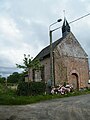
The church.

North side.

East side.
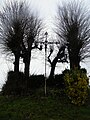
Calvary.
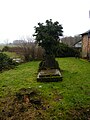
Cemetery.

Water tower.

Body of water.


See also[]
References[]
- ^ "Répertoire national des élus: les maires". data.gouv.fr, Plateforme ouverte des données publiques françaises (in French). 9 August 2021.
- ^ "Populations légales 2018". The National Institute of Statistics and Economic Studies. 28 December 2020.
- ^ "Résultats France - Présidentielle 2017 - 1er et 2nd tour".
| Wikimedia Commons has media related to Épécamps. |
Categories:
- Communes of Somme (department)
- Amiens arrondissement geography stubs