Bettencourt-Rivière
show This article may be expanded with text translated from the corresponding article in French. (May 2012) Click [show] for important translation instructions. |
Bettencourt-Rivière | |
|---|---|
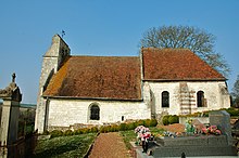
 The church in Bettencourt-Rivière | |
 Coat of arms | |
show Location of Bettencourt-Rivière | |
 Bettencourt-Rivière | |
| Coordinates: 49°59′52″N 1°58′41″E / 49.9978°N 1.9781°ECoordinates: 49°59′52″N 1°58′41″E / 49.9978°N 1.9781°E | |
| Country | France |
| Region | Hauts-de-France |
| Department | Somme |
| Arrondissement | Abbeville |
| Canton | Gamaches |
| Intercommunality | CA Baie de Somme |
| Government | |
| • Mayor (2020–2026) | Michel Deforceville[1] |
| Area 1 | 7.38 km2 (2.85 sq mi) |
| Population (Jan. 2018)[2] | 224 |
| • Density | 30/km2 (79/sq mi) |
| Time zone | UTC+01:00 (CET) |
| • Summer (DST) | UTC+02:00 (CEST) |
| INSEE/Postal code | 80099 /80270 |
| Elevation | 11–94 m (36–308 ft) (avg. 20 m or 66 ft) |
| 1 French Land Register data, which excludes lakes, ponds, glaciers > 1 km2 (0.386 sq mi or 247 acres) and river estuaries. | |


Bettencourt-Rivière is a commune in the Somme department in Hauts-de-France in northern France.
Geography[]
The commune is situated on the D216 road, some 15 miles (24 km) southeast of Abbeville. The commune is made up of two villages: Bettencourt to the west, on the left bank of the small river Airaines and Rivière to the east, on the right bank of the river.
Population[]
| Year | 1962 | 1968 | 1975 | 1982 | 1990 | 1999 | 2006 |
|---|---|---|---|---|---|---|---|
| Population | 166 | 183 | 168 | 161 | 200 | 212 | 226 |
| From the year 1962 on: No double counting—residents of multiple communes (e.g. students and military personnel) are counted only once. | |||||||
Places of interest[]
- Bettencourt church
- Rivière church
Rivière church
See also[]
References[]
- ^ "Répertoire national des élus: les maires". data.gouv.fr, Plateforme ouverte des données publiques françaises (in French). 2 December 2020.
- ^ "Populations légales 2018". INSEE. 28 December 2020.
| Wikimedia Commons has media related to Bettencourt-Rivière. |
Categories:
- Communes of Somme (department)
- Abbeville arrondissement geography stubs