Florensac
Florensac | |
|---|---|
 The church of St-Jean-Baptiste | |
 Coat of arms | |
show Location of Florensac | |
 Florensac | |
| Coordinates: 43°23′01″N 3°27′56″E / 43.3836°N 3.4656°ECoordinates: 43°23′01″N 3°27′56″E / 43.3836°N 3.4656°E | |
| Country | France |
| Region | Occitanie |
| Department | Hérault |
| Arrondissement | Béziers |
| Canton | Pézenas |
| Intercommunality | Hérault Méditerranée |
| Government | |
| • Mayor (2020–2026) | Vincent Gaudy[1] |
| Area 1 | 36.9 km2 (14.2 sq mi) |
| Population (Jan. 2018)[2] | 5,051 |
| • Density | 140/km2 (350/sq mi) |
| Time zone | UTC+01:00 (CET) |
| • Summer (DST) | UTC+02:00 (CEST) |
| INSEE/Postal code | 34101 /34510 |
| Elevation | 1–90 m (3.3–295.3 ft) (avg. 9 m or 30 ft) |
| 1 French Land Register data, which excludes lakes, ponds, glaciers > 1 km2 (0.386 sq mi or 247 acres) and river estuaries. | |


Florensac is a commune in the Hérault department in southern France.

Map
Population[]
| Year | Pop. | ±% |
|---|---|---|
| 1962 | 2,726 | — |
| 1968 | 2,785 | +2.2% |
| 1975 | 2,917 | +4.7% |
| 1982 | 3,064 | +5.0% |
| 1990 | 3,583 | +16.9% |
| 1999 | 3,859 | +7.7% |
| 2008 | 4,731 | +22.6% |
Images[]
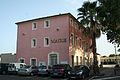
Town hall.

Bridge between Florensac and St. Thibéry.

Florensac Castel build by baron Fernand de Vulliod.

Statue of Marianne.


See also[]
References[]
- ^ "Répertoire national des élus: les maires". data.gouv.fr, Plateforme ouverte des données publiques françaises (in French). 2 December 2020.
- ^ "Populations légales 2018". INSEE. 28 December 2020.
| Wikimedia Commons has media related to Florensac. |
| show Authority control |
|---|
This Hérault geographical article is a stub. You can help Wikipedia by . |
Categories:
- Communes of Hérault
- Hérault geography stubs