Gabian
Gabian | |
|---|---|
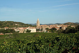 View of Gabian | |
 Coat of arms | |
show Location of Gabian | |
 Gabian | |
| Coordinates: 43°30′52″N 3°16′25″E / 43.5144°N 3.2736°ECoordinates: 43°30′52″N 3°16′25″E / 43.5144°N 3.2736°E | |
| Country | France |
| Region | Occitanie |
| Department | Hérault |
| Arrondissement | Béziers |
| Canton | Cazouls-lès-Béziers |
| Intercommunality | Les Avant-Monts |
| Government | |
| • Mayor (2020–2026) | Francis Boutes[1] |
| Area 1 | 15.96 km2 (6.16 sq mi) |
| Population (Jan. 2018)[2] | 840 |
| • Density | 53/km2 (140/sq mi) |
| Time zone | UTC+01:00 (CET) |
| • Summer (DST) | UTC+02:00 (CEST) |
| INSEE/Postal code | 34109 /34320 |
| Elevation | 82–260 m (269–853 ft) (avg. 121 m or 397 ft) |
| 1 French Land Register data, which excludes lakes, ponds, glaciers > 1 km2 (0.386 sq mi or 247 acres) and river estuaries. | |


Gabian is a commune in the Hérault département in Occitanie in southern France.

Map
Population[]
| Year | Pop. | ±% |
|---|---|---|
| 2006 | 770 | — |
| 2007 | 786 | +2.1% |
| 2008 | 802 | +2.0% |
| 2009 | 810 | +1.0% |
| 2010 | 820 | +1.2% |
| 2011 | 823 | +0.4% |
| 2012 | 827 | +0.5% |
| 2013 | 830 | +0.4% |
| 2014 | 840 | +1.2% |
| 2015 | 842 | +0.2% |
| 2016 | 841 | −0.1% |
Panorama[]

See also[]
References[]
- ^ "Répertoire national des élus: les maires". data.gouv.fr, Plateforme ouverte des données publiques françaises (in French). 2 December 2020.
- ^ "Populations légales 2018". INSEE. 28 December 2020.
| Wikimedia Commons has media related to Gabian. |
| show Authority control |
|---|
This Hérault geographical article is a stub. You can help Wikipedia by . |
Categories:
- Communes of Hérault
- Hérault geography stubs