Loupian
Loupian | |
|---|---|
 Church of Sainte-Cécile | |
 Coat of arms | |
show Location of Loupian | |
 Loupian | |
| Coordinates: 43°27′03″N 3°36′52″E / 43.4508°N 3.6144°ECoordinates: 43°27′03″N 3°36′52″E / 43.4508°N 3.6144°E | |
| Country | France |
| Region | Occitanie |
| Department | Hérault |
| Arrondissement | Montpellier |
| Canton | Mèze |
| Intercommunality | CA Sète Agglopôle Méditerranée |
| Government | |
| • Mayor (2020–2026) | Alain Vidal |
| Area 1 | 16.00 km2 (6.18 sq mi) |
| Population (Jan. 2018)[1] | 2,176 |
| • Density | 140/km2 (350/sq mi) |
| Time zone | UTC+01:00 (CET) |
| • Summer (DST) | UTC+02:00 (CEST) |
| INSEE/Postal code | 34143 /34140 |
| Elevation | 0–170 m (0–558 ft) (avg. 2 m or 6.6 ft) |
| 1 French Land Register data, which excludes lakes, ponds, glaciers > 1 km2 (0.386 sq mi or 247 acres) and river estuaries. | |


Loupian (French pronunciation: [lupjɑ̃]; Occitan: Lopian) is a commune in the Hérault département in southern France.

Map
Population[]
| Year | Pop. | ±% |
|---|---|---|
| 1962 | 871 | — |
| 1968 | 901 | +3.4% |
| 1975 | 934 | +3.7% |
| 1982 | 1,113 | +19.2% |
| 1990 | 1,289 | +15.8% |
| 1999 | 1,483 | +15.1% |
| 2008 | 2,085 | +40.6% |
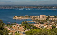
Loupian and the Étang de Thau from Sète.

"Saint-Félix" and the Étang de Thau.
See also[]
References[]
- ^ "Populations légales 2018". INSEE. 28 December 2020.
| Wikimedia Commons has media related to Loupian. |
| show Authority control |
|---|
This Hérault geographical article is a stub. You can help Wikipedia by . |
Categories:
- Communes of Hérault
- Hérault geography stubs