Paimpont
Paimpont
Pempont | |
|---|---|
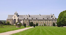 Abbey | |
 Coat of arms | |
show Location of Paimpont | |
 Paimpont | |
| Coordinates: 48°01′08″N 2°10′11″W / 48.0189°N 2.1697°WCoordinates: 48°01′08″N 2°10′11″W / 48.0189°N 2.1697°W | |
| Country | France |
| Region | Brittany |
| Department | Ille-et-Vilaine |
| Arrondissement | Rennes |
| Canton | Montfort-sur-Meu |
| Intercommunality | Brocéliande |
| Government | |
| • Mayor (2020–2026) | Alain Lefeuvre |
| Area 1 | 110.28 km2 (42.58 sq mi) |
| Population (Jan. 2018)[1] | 1,755 |
| • Density | 16/km2 (41/sq mi) |
| Time zone | UTC+01:00 (CET) |
| • Summer (DST) | UTC+02:00 (CEST) |
| INSEE/Postal code | 35211 /35380 |
| Elevation | 62–258 m (203–846 ft) (avg. 160 m or 520 ft) |
| 1 French Land Register data, which excludes lakes, ponds, glaciers > 1 km2 (0.386 sq mi or 247 acres) and river estuaries. | |


Paimpont (Breton: Pempont, Gallo: Penpont) is a commune in the Ille-et-Vilaine department in Brittany in northwestern France.
The name is a compound of Old Breton pen "head" and the Latin borrowing pont "bridge" and is first attested in the 9th century in the Latinised form Caput Pontis and then in 870 CE as Penpont.[2] The town grew up around the , which was founded by the Breton king and Catholic saint Judicael in 645 CE on the shore of a small lake now known as the Étang de Paimpont.[3]
Population[]
Inhabitants of Paimpont are called Paimpontais in French.
| Year | Pop. | ±% |
|---|---|---|
| 1962 | 1,637 | — |
| 1968 | 1,714 | +4.7% |
| 1975 | 1,559 | −9.0% |
| 1982 | 1,449 | −7.1% |
| 1990 | 1,385 | −4.4% |
| 1999 | 1,395 | +0.7% |
| 2008 | 1,641 | +17.6% |
See also[]
- Paimpont forest
- Communes of the Ille-et-Vilaine department
References[]
- ^ "Populations légales 2018". INSEE. 28 December 2020.
- ^ Dauzat, Albert; Rostaing, Charles (1979). Dictionnaire étymologique des noms de lieu en France. Paris: Librairie Guénégaud. pp. 515–6. ISBN 2-85023-076-6.
- ^ "Abbaye de Paimpont". Brocéliande (in French). Retrieved 2020-08-14.
External links[]
| Wikimedia Commons has media related to Paimpont. |
- Official website Paimpont (in French)
- Cultural Heritage (in French)
- www.paimpont.org (in French)
| show Communes of the Ille-et-Vilaine department |
|---|
| show Authority control |
|---|
This Ille-et-Vilaine geographical article is a stub. You can help Wikipedia by . |
Categories:
- Communes of Ille-et-Vilaine
- Ille-et-Vilaine geography stubs