Bruyères
show This article may be expanded with text translated from the corresponding article in French. (April 2020) Click [show] for important translation instructions. |
Bruyères | |
|---|---|
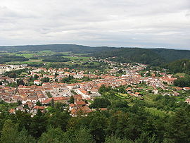 A general view of Bruyères | |
 Coat of arms | |
show Location of Bruyères | |
 Bruyères | |
| Coordinates: 48°12′30″N 6°43′16″E / 48.2083°N 06.721°ECoordinates: 48°12′30″N 6°43′16″E / 48.2083°N 06.721°E | |
| Country | France |
| Region | Grand Est |
| Department | Vosges |
| Arrondissement | Épinal |
| Canton | Bruyères |
| Intercommunality | CC Bruyères - Vallons des Vosges |
| Government | |
| • Mayor (2020–2026) | Denis Masy[1] |
| Area 1 | 16.02 km2 (6.19 sq mi) |
| Population (Jan. 2018)[2] | 3,078 |
| • Density | 190/km2 (500/sq mi) |
| Time zone | UTC+01:00 (CET) |
| • Summer (DST) | UTC+02:00 (CEST) |
| INSEE/Postal code | 88078 /88600 |
| Elevation | 390–704 m (1,280–2,310 ft) (avg. 493 m or 1,617 ft) |
| 1 French Land Register data, which excludes lakes, ponds, glaciers > 1 km2 (0.386 sq mi or 247 acres) and river estuaries. | |


Bruyères is a commune in the Vosges department in Grand Est in northeastern France.
The town built up around a castle built on a hill in the locality in the 6th century. It was the birthplace of Jean Lurçat, in 1892.
History[]
In World War II, Bruyères was liberated from German occupation by Japanese-American soldiers of the 442nd Regimental Combat Team. The Battle of Bruyères and the rescue of the "Lost Texas Battalion" is now considered to be one of the ten major military battles fought by the United States Armed Forces. The 100th/442nd Regiment became the most decorated Unit in the History of the US Army (8 Presidential Unit Citation, 21 Medal of Honor and 18,143 individual decorations). On July 8 & 9, 1989, the bicentennial of the presentation of the "Bill of Human Rights" by Mounier, Pierre Moulin created and inaugurated the "Peace and Freedom Trail." Encompassing 89 points of interest, the "Peace and Freedom Trail" highlights the actions of the 442nd RCT and their campaign to free Bruyères from German occupation during World War II.
Notable residents[]
- Gaston About
Twin towns[]
- Vielsalm (
 Belgium)
 - Honolulu (
 United States)
See also[]
References[]
- ^ "Répertoire national des élus: les maires". data.gouv.fr, Plateforme ouverte des données publiques françaises (in French). 2 December 2020. Retrieved 7 December 2020.
- ^ "Populations légales 2018". INSEE. 28 December 2020.
External links[]
| Wikimedia Commons has media related to Bruyères. |
- Town website (in French)
- [1] Le Chemin de la Paix et de la Liberte de Bruyeres
| show Authority control |
|---|
This Vosges geographical article is a stub. You can help Wikipedia by . |
- Communes of Vosges (department)
- Vosges (department) geography stubs