They-sous-Montfort
This article includes a list of references, related reading or external links, but its sources remain unclear because it lacks inline citations. (September 2018) |
They-sous-Montfort | |
|---|---|
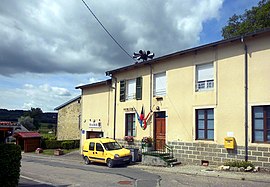 The town hall in They-sous-Montfort | |
 Coat of arms | |
show Location of They-sous-Montfort | |
 They-sous-Montfort | |
| Coordinates: 48°13′55″N 5°58′32″E / 48.2319°N 5.9756°ECoordinates: 48°13′55″N 5°58′32″E / 48.2319°N 5.9756°E | |
| Country | France |
| Region | Grand Est |
| Department | Vosges |
| Arrondissement | Neufchâteau |
| Canton | Vittel |
| Intercommunality | CC Terre d'eau |
| Government | |
| • Mayor (2008–2014) | Franck Deguisne |
| Area 1 | 10.21 km2 (3.94 sq mi) |
| Population (Jan. 2018)[1] | 128 |
| • Density | 13/km2 (32/sq mi) |
| Time zone | UTC+01:00 (CET) |
| • Summer (DST) | UTC+02:00 (CEST) |
| INSEE/Postal code | 88466 /88800 |
| Elevation | 330–470 m (1,080–1,540 ft) |
| 1 French Land Register data, which excludes lakes, ponds, glaciers > 1 km2 (0.386 sq mi or 247 acres) and river estuaries. | |


They-sous-Montfort is a commune in the Vosges department in Grand Est in northeastern France.
See also[]
References[]
- ^ "Populations légales 2018". INSEE. 28 December 2020.
| Wikimedia Commons has media related to They-sous-Montfort. |
This Vosges geographical article is a stub. You can help Wikipedia by . |
Categories:
- Communes of Vosges (department)
- Vosges (department) geography stubs