Ménarmont
Ménarmont | |
|---|---|
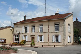 The town hall in Ménarmont | |
show Location of Ménarmont | |
 Ménarmont | |
| Coordinates: 48°25′18″N 6°38′37″E / 48.4217°N 6.6436°ECoordinates: 48°25′18″N 6°38′37″E / 48.4217°N 6.6436°E | |
| Country | France |
| Region | Grand Est |
| Department | Vosges |
| Arrondissement | Épinal |
| Canton | Raon-l'Étape |
| Intercommunality | CC Région de Rambervillers |
| Government | |
| • Mayor (2020–2026) | Patrick Pierillas |
| Area 1 | 5.24 km2 (2.02 sq mi) |
| Population (Jan. 2018)[1] | 71 |
| • Density | 14/km2 (35/sq mi) |
| Time zone | UTC+01:00 (CET) |
| • Summer (DST) | UTC+02:00 (CEST) |
| INSEE/Postal code | 88298 /88700 |
| Elevation | 265–347 m (869–1,138 ft) (avg. 290 m or 950 ft) |
| 1 French Land Register data, which excludes lakes, ponds, glaciers > 1 km2 (0.386 sq mi or 247 acres) and river estuaries. | |


Ménarmont is a commune in the Vosges department in Grand Est in northeastern France.
Geography[]
The village is on the northern edge of the Vosges, on the departmental frontier with the département of Meurthe et Moselle.
The countryside here is less densely populated than that closer to Épinal (some 30 kilometres / 20 miles to the south-south-west), and since 1977 the local landfill site has welcomed 150,000 tonnes annually of domestic and industrial waste. Plans to extend the site after it became full in 2005 were hotly contested by neighbouring communes, notably Bazien to the north-west.
See also[]
References[]
- ^ "Populations légales 2018". INSEE. 28 December 2020.
| Wikimedia Commons has media related to Ménarmont. |
This Vosges geographical article is a stub. You can help Wikipedia by . |
Categories:
- Communes of Vosges (department)
- Vosges (department) geography stubs