Connezac
Connezac | |
|---|---|
 The town hall in Connezac | |
show Location of Connezac | |
 Connezac | |
| Coordinates: 45°30′40″N 0°31′41″E / 45.5112°N 0.528°ECoordinates: 45°30′40″N 0°31′41″E / 45.5112°N 0.528°E | |
| Country | France |
| Region | Nouvelle-Aquitaine |
| Department | Dordogne |
| Arrondissement | Nontron |
| Canton | Périgord Vert Nontronnais |
| Intercommunality | Périgord Nontronnais |
| Government | |
| • Mayor (2020–2026) | Thierry Pasquet |
| Area 1 | 5.78 km2 (2.23 sq mi) |
| Population (Jan. 2018)[1] | 73 |
| • Density | 13/km2 (33/sq mi) |
| Time zone | UTC+01:00 (CET) |
| • Summer (DST) | UTC+02:00 (CEST) |
| INSEE/Postal code | 24131 /24300 |
| Elevation | 118–209 m (387–686 ft) |
| 1 French Land Register data, which excludes lakes, ponds, glaciers > 1 km2 (0.386 sq mi or 247 acres) and river estuaries. | |


Connezac (French pronunciation: [kɔnzak]; Occitan: Conasac) is a commune in the Dordogne department in Nouvelle-Aquitaine in southwestern France. The commune consists of 5 hamlets: Connezac (where the church and the castle are located), Maine Rousset (where the town hall is located), Fontenille, Lafarge and Maine du Bost.
Population[]
| Year | Pop. | ±% |
|---|---|---|
| 1962 | 101 | — |
| 1968 | 111 | +9.9% |
| 1975 | 103 | −7.2% |
| 1982 | 91 | −11.7% |
| 1990 | 56 | −38.5% |
| 1999 | 82 | +46.4% |
| 2008 | 83 | +1.2% |
Monuments[]
- Castle of Connezac (16th and 17th century)
- Parish church Saint Martin, former chapel of the castle.
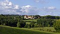
Looking from Connezac to Belussière castle

Church
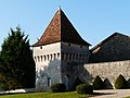
Connezac château

St Martins nave


See also[]
References[]
- ^ "Populations légales 2018". INSEE. 28 December 2020.
| Wikimedia Commons has media related to Connezac. |
| show Authority control |
|---|
This Dordogne geographical article is a stub. You can help Wikipedia by . |
Categories:
- Communes of Dordogne
- Dordogne geography stubs