Les Farges
Les Farges | |
|---|---|
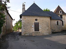 The chapel in Les Farges | |
show Location of Les Farges | |
 Les Farges | |
| Coordinates: 45°06′58″N 1°11′15″E / 45.1161°N 1.1875°ECoordinates: 45°06′58″N 1°11′15″E / 45.1161°N 1.1875°E | |
| Country | France |
| Region | Nouvelle-Aquitaine |
| Department | Dordogne |
| Arrondissement | Sarlat-la-Canéda |
| Canton | Vallée de l'Homme |
| Intercommunality | Vallée de l'Homme |
| Government | |
| • Mayor (2020–2026) | Sylvie Colombel |
| Area 1 | 8.14 km2 (3.14 sq mi) |
| Population (Jan. 2018)[1] | 320 |
| • Density | 39/km2 (100/sq mi) |
| Time zone | UTC+01:00 (CET) |
| • Summer (DST) | UTC+02:00 (CEST) |
| INSEE/Postal code | 24175 /24290 |
| Elevation | 71–267 m (233–876 ft) (avg. 250 m or 820 ft) |
| 1 French Land Register data, which excludes lakes, ponds, glaciers > 1 km2 (0.386 sq mi or 247 acres) and river estuaries. | |


Les Farges (French pronunciation: [le faʁʒ]; Occitan: Las Farjas) is a commune in the Dordogne department in Nouvelle-Aquitaine in southwestern France.
Population[]
| Year | Pop. | ±% |
|---|---|---|
| 1962 | 151 | — |
| 1968 | 151 | +0.0% |
| 1975 | 159 | +5.3% |
| 1982 | 180 | +13.2% |
| 1990 | 228 | +26.7% |
| 1999 | 262 | +14.9% |
| 2008 | 324 | +23.7% |
See also[]
References[]
- ^ "Populations légales 2018". INSEE. 28 December 2020.
| Wikimedia Commons has media related to Les Farges. |
| show Authority control |
|---|
This Dordogne geographical article is a stub. You can help Wikipedia by . |
Categories:
- Communes of Dordogne
- Dordogne geography stubs