Plazac
show This article may be expanded with text translated from the corresponding article in French. (August 2013) Click [show] for important translation instructions. |
Plazac | |
|---|---|
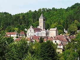 A general view of Plazac | |
 Coat of arms | |
show Location of Plazac | |
 Plazac | |
| Coordinates: 45°02′09″N 1°02′25″E / 45.0358°N 1.0403°ECoordinates: 45°02′09″N 1°02′25″E / 45.0358°N 1.0403°E | |
| Country | France |
| Region | Nouvelle-Aquitaine |
| Department | Dordogne |
| Arrondissement | Sarlat-la-Canéda |
| Canton | Vallée de l'Homme |
| Government | |
| • Mayor (2020–2026) | Florence Gauthier[1] |
| Area 1 | 33.77 km2 (13.04 sq mi) |
| Population (Jan. 2018)[2] | 689 |
| • Density | 20/km2 (53/sq mi) |
| Time zone | UTC+01:00 (CET) |
| • Summer (DST) | UTC+02:00 (CEST) |
| INSEE/Postal code | 24330 /24580 |
| Elevation | 82–289 m (269–948 ft) (avg. 100 m or 330 ft) |
| 1 French Land Register data, which excludes lakes, ponds, glaciers > 1 km2 (0.386 sq mi or 247 acres) and river estuaries. | |


Plazac (French pronunciation: [plazak]; Occitan: Plasac) is a commune in the Dordogne department in Nouvelle-Aquitaine in southwestern France. It is near the village of Les Eyzies and the city of Sarlat-la-Canéda.
The bishops of Périgueux built a fortified residence in Plazac in the 12th-13th century. Its donjon was transformed into a bell tower in the 17th century. Its chapel is now the village church. One wing of the residence has been preserved.[3]
During World War II, Plazac sheltered the residents of Bootzheim (Alsace) who were evacuated.[4]
Population[]
| Year | Pop. | ±% |
|---|---|---|
| 1962 | 522 | — |
| 1968 | 424 | −18.8% |
| 1975 | 427 | +0.7% |
| 1982 | 502 | +17.6% |
| 1990 | 543 | +8.2% |
| 1999 | 578 | +6.4% |
| 2008 | 736 | +27.3% |
See also[]
References[]
- ^ "Répertoire national des élus: les maires". data.gouv.fr, Plateforme ouverte des données publiques françaises (in French). 2 December 2020.
- ^ "Populations légales 2018". INSEE. 28 December 2020.
- ^ Base Mérimée: Château des Evêques et ancien cimetière, Ministère français de la Culture. (in French)
- ^ Jumelage Bootzheim / Plazac
| Wikimedia Commons has media related to Plazac. |
| show Authority control |
|---|
Categories:
- Communes of Dordogne