Ribagnac
From Wikipedia, the free encyclopedia
Commune in Nouvelle-Aquitaine, France
Ribagnac | |
|---|---|
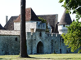 Chateau of Bridoire | |
 Ribagnac  Ribagnac | |
Coordinates:  44°46′00″N 0°29′57″E / 44.7667°N 0.4992°E / 44.7667; 0.4992Coordinates: 44°46′00″N 0°29′57″E / 44.7667°N 0.4992°E / 44.7667; 0.4992 44°46′00″N 0°29′57″E / 44.7667°N 0.4992°E / 44.7667; 0.4992Coordinates: 44°46′00″N 0°29′57″E / 44.7667°N 0.4992°E / 44.7667; 0.4992 | |
| Country | France |
| Region | Nouvelle-Aquitaine |
| Department | Dordogne |
| Arrondissement | Bergerac |
| Canton | Sud-Bergeracois |
| Government | |
| • Mayor (2008–2014) | Marcel Rondonnier |
| Area 1 | 11.81 km2 (4.56 sq mi) |
| Population (Jan. 2018)[1] | 311 |
| • Density | 26/km2 (68/sq mi) |
| Time zone | UTC+01:00 (CET) |
| • Summer (DST) | UTC+02:00 (CEST) |
| INSEE/Postal code | 24351 /24240 |
| Elevation | 78–183 m (256–600 ft) (avg. 153 m or 502 ft) |
| 1 French Land Register data, which excludes lakes, ponds, glaciers > 1 km2 (0.386 sq mi or 247 acres) and river estuaries. | |

Ribagnac is a commune in the Dordogne department in Nouvelle-Aquitaine in southwestern France.
Population[]
| Year | Pop. | ±% |
|---|---|---|
| 1962 | 246 | — |
| 1968 | 225 | −8.5% |
| 1975 | 193 | −14.2% |
| 1982 | 224 | +16.1% |
| 1990 | 278 | +24.1% |
| 1999 | 291 | +4.7% |
| 2008 | 314 | +7.9% |
See also[]
References[]
- ^ "Populations légales 2018". INSEE. 28 December 2020.
| Wikimedia Commons has media related to Ribagnac. |
| show Authority control | |
|---|---|
| General |
|
| National libraries | |
This Dordogne geographical article is a stub. You can help Wikipedia by . |
- v
- t
Retrieved from ""
Categories:
- Communes of Dordogne
- Dordogne geography stubs
Hidden categories:
- Articles with short description
- Short description is different from Wikidata
- Infobox mapframe without OSM relation ID on Wikidata
- Coordinates on Wikidata
- Pages using infobox settlement with image map1 but not image map
- Commons category link from Wikidata
- Articles with VIAF identifiers
- Articles with BNF identifiers
- Articles with WorldCat-VIAF identifiers
- All stub articles
- Pages using the Kartographer extension