Sergeac
Sergeac | |
|---|---|
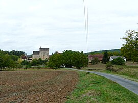 A general view of Sergeac | |
show Location of Sergeac | |
 Sergeac | |
| Coordinates: 45°00′12″N 1°06′26″E / 45.0033°N 1.1072°ECoordinates: 45°00′12″N 1°06′26″E / 45.0033°N 1.1072°E | |
| Country | France |
| Region | Nouvelle-Aquitaine |
| Department | Dordogne |
| Arrondissement | Sarlat-la-Canéda |
| Canton | Vallée de l'Homme |
| Government | |
| • Mayor (2008–2014) | Jean-Pierre Lagarde |
| Area 1 | 10.71 km2 (4.14 sq mi) |
| Population (Jan. 2018)[1] | 214 |
| • Density | 20/km2 (52/sq mi) |
| Time zone | UTC+01:00 (CET) |
| • Summer (DST) | UTC+02:00 (CEST) |
| INSEE/Postal code | 24531 /24290 |
| Elevation | 66–271 m (217–889 ft) (avg. 70 m or 230 ft) |
| 1 French Land Register data, which excludes lakes, ponds, glaciers > 1 km2 (0.386 sq mi or 247 acres) and river estuaries. | |


Sergeac is a commune in the Dordogne department in Nouvelle-Aquitaine in southwestern France.
Population[]
The area of Sergeac is 10,71 km2 for a growing population density of approximately 17,93 habs/km2.[2] From the twenty-first century on, the actual census of municipalities with fewer than 10000 inhabitants are held every five years. For Sergeac, this corresponds to 2004, 2009, etc. Other dates "censuses" (2006, etc.) are legal estimates.
| Year | Pop. | ±% |
|---|---|---|
| 1962 | 169 | — |
| 1968 | 137 | −18.9% |
| 1975 | 142 | +3.6% |
| 1982 | 133 | −6.3% |
| 1990 | 156 | +17.3% |
| 1999 | 172 | +10.3% |
| 2008 | 198 | +15.1% |
Gallery[]
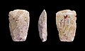
Neolithic polished ax - Muséum de Toulouse.

See also[]
References[]
- ^ "Populations légales 2018". INSEE. 28 December 2020.
- ^ Map France. "Sergeac Housing". Map-France.com. Retrieved 16 February 2012.
External links[]
| Wikimedia Commons has media related to Sergeac. |
| show Authority control |
|---|
This Dordogne geographical article is a stub. You can help Wikipedia by . |
Categories:
- Communes of Dordogne
- Dordogne geography stubs