Villamblard
show This article may be expanded with text translated from the corresponding article in French. (July 2014) Click [show] for important translation instructions. |
Villamblard | |
|---|---|
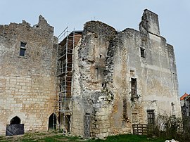 Chateau Barrière | |
 Coat of arms | |
show Location of Villamblard | |
 Villamblard | |
| Coordinates: 45°01′22″N 0°32′27″E / 45.0228°N 0.5408°ECoordinates: 45°01′22″N 0°32′27″E / 45.0228°N 0.5408°E | |
| Country | France |
| Region | Nouvelle-Aquitaine |
| Department | Dordogne |
| Arrondissement | Périgueux |
| Canton | Périgord Central |
| Intercommunality | Isle et Crempse en Périgord |
| Government | |
| • Mayor (2020–2026) | Jean-Luc Alary |
| Area 1 | 20.43 km2 (7.89 sq mi) |
| Population (Jan. 2018)[1] | 894 |
| • Density | 44/km2 (110/sq mi) |
| Time zone | UTC+01:00 (CET) |
| • Summer (DST) | UTC+02:00 (CEST) |
| INSEE/Postal code | 24581 /24140 |
| Elevation | 100–222 m (328–728 ft) (avg. 60 m or 200 ft) |
| 1 French Land Register data, which excludes lakes, ponds, glaciers > 1 km2 (0.386 sq mi or 247 acres) and river estuaries. | |


Villamblard (French pronunciation: [vilɑ̃blaʁ]; Occitan: Vilamblard) is a commune in the Dordogne department in Nouvelle-Aquitaine in southwestern France.
Population[]
| Year | Pop. | ±% |
|---|---|---|
| 1962 | 815 | — |
| 1968 | 799 | −2.0% |
| 1975 | 841 | +5.3% |
| 1982 | 823 | −2.1% |
| 1990 | 813 | −1.2% |
| 1999 | 823 | +1.2% |
| 2008 | 900 | +9.4% |
See also[]
References[]
- ^ "Populations légales 2018". INSEE. 28 December 2020.
| Wikimedia Commons has media related to Villamblard. |
| show Authority control |
|---|
This Dordogne geographical article is a stub. You can help Wikipedia by . |
Categories:
- Communes of Dordogne
- Dordogne geography stubs