Agenvillers
From Wikipedia, the free encyclopedia
Commune in Hauts-de-France, France
Commune in Hauts-de-France, France
Agenvillers | |
|---|---|
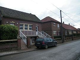 The town hall and school of Agenvillers | |
 Agenvillers  Agenvillers | |
Coordinates:  50°10′45″N 1°55′13″E / 50.1792°N 1.9203°E / 50.1792; 1.9203Coordinates: 50°10′45″N 1°55′13″E / 50.1792°N 1.9203°E / 50.1792; 1.9203 50°10′45″N 1°55′13″E / 50.1792°N 1.9203°E / 50.1792; 1.9203Coordinates: 50°10′45″N 1°55′13″E / 50.1792°N 1.9203°E / 50.1792; 1.9203 | |
| Country | France |
| Region | Hauts-de-France |
| Department | Somme |
| Arrondissement | Abbeville |
| Canton | Abbeville-1 |
| Intercommunality | Ponthieu-Marquenterre |
| Government | |
| • Mayor (2014-2020) | Ghyslain Hécquet |
| Area 1 | 5.98 km2 (2.31 sq mi) |
| Population (Jan. 2018)[1] | 242 |
| • Density | 40/km2 (100/sq mi) |
| Time zone | UTC+01:00 (CET) |
| • Summer (DST) | UTC+02:00 (CEST) |
| INSEE/Postal code | 80006 /80150 |
| Elevation | 58–85 m (190–279 ft) (avg. 84 m or 276 ft) |
| 1 French Land Register data, which excludes lakes, ponds, glaciers > 1 km2 (0.386 sq mi or 247 acres) and river estuaries. | |

Agenvillers is a commune in the Somme department in Hauts-de-France in northern France.
Geography[]
The communes is a small village about 13 km (8 mi) northeast of Abbeville, on the D82 departmental road.
Population[]
| Year | Pop. | ±% |
|---|---|---|
| 2006 | 191 | — |
| 2007 | 192 | +0.5% |
| 2008 | 191 | −0.5% |
| 2009 | 193 | +1.0% |
| 2010 | 193 | +0.0% |
| 2011 | 194 | +0.5% |
| 2012 | 195 | +0.5% |
| 2013 | 198 | +1.5% |
| 2014 | 197 | −0.5% |
| 2015 | 207 | +5.1% |
| 2016 | 218 | +5.3% |
See also[]
Communes of the Somme department
References[]
- ^ "Populations légales 2018". INSEE. 28 December 2020.
External links[]
| Wikimedia Commons has media related to Agenvillers. |
(All French language)
show
Communes of the Somme department | |
|---|---|
|
This Arrondissement of Abbeville geographical article is a stub. You can help Wikipedia by . |
- v
- t
Retrieved from ""
Categories:
- Communes of Somme (department)
- Abbeville arrondissement geography stubs
Hidden categories:
- Articles with short description
- Short description is different from Wikidata
- Infobox mapframe without OSM relation ID on Wikidata
- Coordinates on Wikidata
- Pages using infobox settlement with image map1 but not image map
- Commons category link is on Wikidata
- Articles with BNF identifiers
- All stub articles
- Pages using the Kartographer extension