Arry, Somme
Arry | |
|---|---|
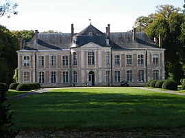 The castle in Arry. | |
show Location of Arry | |
 Arry | |
| Coordinates: 50°16′44″N 1°43′17″E / 50.279°N 1.7214°ECoordinates: 50°16′44″N 1°43′17″E / 50.279°N 1.7214°E | |
| Country | France |
| Region | Hauts-de-France |
| Department | Somme |
| Arrondissement | Abbeville |
| Canton | Rue |
| Intercommunality | CC Ponthieu-Marquenterre |
| Government | |
| • Mayor (2020-2026) | Thibault Bourgois |
| Area 1 | 7.34 km2 (2.83 sq mi) |
| Population (Jan. 2018)[1] | 215 |
| • Density | 29/km2 (76/sq mi) |
| Time zone | UTC+01:00 (CET) |
| • Summer (DST) | UTC+02:00 (CEST) |
| INSEE/Postal code | 80030 /80120 |
| Elevation | 2–39 m (6.6–128.0 ft) (avg. 16 m or 52 ft) |
| 1 French Land Register data, which excludes lakes, ponds, glaciers > 1 km2 (0.386 sq mi or 247 acres) and river estuaries. | |


Arry is a commune in the Somme department in Hauts-de-France in northern France.
Geography[]
The commune is situated about 1 kilometre from the A16 autoroute, on the D938 road to Rue.
Population[]
| Year | 1962 | 1968 | 1975 | 1982 | 1990 | 1999 | 2006 | 2015 |
|---|---|---|---|---|---|---|---|---|
| Population | 155 | 182 | 191 | 176 | 158 | 164 | 165 | 205 |
| From the year 1962 on: No double counting—residents of multiple communes (e.g. students and military personnel) are counted only once. | ||||||||
Monument aux morts[]
The monument aux morts in this commune features a sculpture by Louis-Henri Leclabart. A montage of photographs of this monument aux morts, which stands in front of the church, is shown below.
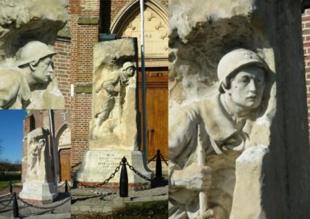
The Arry monument aux morts.
See also[]
References[]
- ^ "Populations légales 2018". INSEE. 28 December 2020.
| Wikimedia Commons has media related to Arry (Somme). |
Categories:
- Communes of Somme (department)
- Abbeville arrondissement geography stubs