Bézéril
Bézéril | |
|---|---|
 The Château | |
Location of Bézéril  | |
 Bézéril | |
| Coordinates: 43°32′40″N 0°52′43″E / 43.5444°N 0.8786°ECoordinates: 43°32′40″N 0°52′43″E / 43.5444°N 0.8786°E | |
| Country | France |
| Region | Occitanie |
| Department | Gers |
| Arrondissement | Auch |
| Canton | Val de Save |
| Intercommunality | Savès |
| Government | |
| • Mayor (2020–2026) | Christian Daignan |
| Area 1 | 9.65 km2 (3.73 sq mi) |
| Population (Jan. 2018)[1] | 129 |
| • Density | 13/km2 (35/sq mi) |
| Time zone | UTC+01:00 (CET) |
| • Summer (DST) | UTC+02:00 (CEST) |
| INSEE/Postal code | 32051 /32130 |
| Elevation | 172–272 m (564–892 ft) (avg. 234 m or 768 ft) |
| 1 French Land Register data, which excludes lakes, ponds, glaciers > 1 km2 (0.386 sq mi or 247 acres) and river estuaries. | |


Bézéril (French pronunciation: [bezeʁil]; Occitan: Beserilh) is a commune in the Gers department in southwestern France.
Geography[]
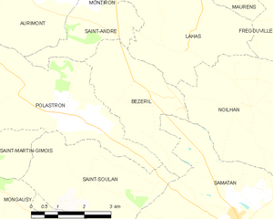
Bézéril and its surrounding communes
Population[]
| Year | Pop. | ±% |
|---|---|---|
| 1962 | 144 | — |
| 1968 | 123 | −14.6% |
| 1975 | 113 | −8.1% |
| 1982 | 113 | +0.0% |
| 1990 | 107 | −5.3% |
| 1999 | 92 | −14.0% |
| 2008 | 102 | +10.9% |
See also[]
- Communes of the Gers department
References[]
- ^ "Populations légales 2018". The National Institute of Statistics and Economic Studies. 28 December 2020.
| Wikimedia Commons has media related to Bézéril. |
This Gers geographical article is a stub. You can help Wikipedia by . |
Categories:
- Communes of Gers
- Gers geography stubs