Monlaur-Bernet
Monlaur-Bernet | |
|---|---|
 The church in Monlaur-Bernet | |
show Location of Monlaur-Bernet | |
 Monlaur-Bernet | |
| Coordinates: 43°21′09″N 0°30′45″E / 43.3525°N 0.5125°ECoordinates: 43°21′09″N 0°30′45″E / 43.3525°N 0.5125°E | |
| Country | France |
| Region | Occitanie |
| Department | Gers |
| Arrondissement | Mirande |
| Canton | Astarac-Gimone |
| Intercommunality | Val de Gers |
| Government | |
| • Mayor (2020–2026) | Fabienne Nassans |
| Area 1 | 12.21 km2 (4.71 sq mi) |
| Population (Jan. 2018)[1] | 164 |
| • Density | 13/km2 (35/sq mi) |
| Time zone | UTC+01:00 (CET) |
| • Summer (DST) | UTC+02:00 (CEST) |
| INSEE/Postal code | 32272 /32140 |
| Elevation | 237–376 m (778–1,234 ft) (avg. 360 m or 1,180 ft) |
| 1 French Land Register data, which excludes lakes, ponds, glaciers > 1 km2 (0.386 sq mi or 247 acres) and river estuaries. | |


Monlaur-Bernet (French pronunciation: [mɔ̃lɔʁ bɛʁnɛ]; Occitan: Montlaur e Vernet) is a commune in the Gers department in southwestern France.
Geography[]
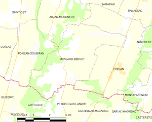
Monlaur-Bernet and its surrounding communes
Population[]
| Year | Pop. | ±% |
|---|---|---|
| 1962 | 296 | — |
| 1968 | 263 | −11.1% |
| 1975 | 246 | −6.5% |
| 1982 | 205 | −16.7% |
| 1990 | 189 | −7.8% |
| 1999 | 161 | −14.8% |
| 2008 | 169 | +5.0% |
See also[]
- Communes of the Gers department
References[]
- ^ "Populations légales 2018". INSEE. 28 December 2020.
| Wikimedia Commons has media related to Monlaur-Bernet. |
| show Communes of the Gers department |
|---|
This Gers geographical article is a stub. You can help Wikipedia by . |
Categories:
- Communes of Gers
- Gers geography stubs