Sainte-Christie-d'Armagnac
Sainte-Christie-d'Armagnac | |
|---|---|
 The town hall in Sainte-Christie-d'Armagnac | |
show Location of Sainte-Christie-d'Armagnac | |
 Sainte-Christie-d'Armagnac | |
| Coordinates: 43°47′07″N 0°00′27″W / 43.7853°N 0.0075°WCoordinates: 43°47′07″N 0°00′27″W / 43.7853°N 0.0075°W | |
| Country | France |
| Region | Occitanie |
| Department | Gers |
| Arrondissement | Condom |
| Canton | Grand-Bas-Armagnac |
| Government | |
| • Mayor (2008–2014) | Pierre Barrail |
| Area 1 | 22.5 km2 (8.7 sq mi) |
| Population (Jan. 2018)[1] | 376 |
| • Density | 17/km2 (43/sq mi) |
| Time zone | UTC+01:00 (CET) |
| • Summer (DST) | UTC+02:00 (CEST) |
| INSEE/Postal code | 32369 /32370 |
| Elevation | 85–175 m (279–574 ft) |
| 1 French Land Register data, which excludes lakes, ponds, glaciers > 1 km2 (0.386 sq mi or 247 acres) and river estuaries. | |


Sainte-Christie-d'Armagnac is a commune in the Gers department in southwestern France.
Geography[]
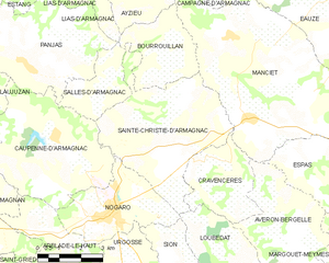
Saint-Christie-d'Armagnac and its surrounding communes
Population[]
| Year | Pop. | ±% |
|---|---|---|
| 1962 | 504 | — |
| 1968 | 453 | −10.1% |
| 1975 | 402 | −11.3% |
| 1982 | 365 | −9.2% |
| 1990 | 360 | −1.4% |
| 1999 | 338 | −6.1% |
| 2008 | 348 | +3.0% |
See also[]
- Communes of the Gers department
References[]
- ^ "Populations légales 2018". INSEE. 28 December 2020.
| Wikimedia Commons has media related to Sainte-Christie-d'Armagnac. |
| show Communes of the Gers department |
|---|
This Gers geographical article is a stub. You can help Wikipedia by . |
Categories:
- Communes of Gers
- Gers geography stubs