Noulens
Noulens | |
|---|---|
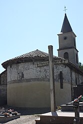 The church in Noulens | |
show Location of Noulens | |
 Noulens | |
| Coordinates: 43°48′38″N 0°09′58″E / 43.8106°N 0.1661°ECoordinates: 43°48′38″N 0°09′58″E / 43.8106°N 0.1661°E | |
| Country | France |
| Region | Occitanie |
| Department | Gers |
| Arrondissement | Condom |
| Canton | Fezensac |
| Government | |
| • Mayor (2008–2014) | Andrée Montaret |
| Area 1 | 5.74 km2 (2.22 sq mi) |
| Population (Jan. 2018)[1] | 102 |
| • Density | 18/km2 (46/sq mi) |
| Time zone | UTC+01:00 (CET) |
| • Summer (DST) | UTC+02:00 (CEST) |
| INSEE/Postal code | 32299 /32800 |
| Elevation | 132–196 m (433–643 ft) (avg. 160 m or 520 ft) |
| 1 French Land Register data, which excludes lakes, ponds, glaciers > 1 km2 (0.386 sq mi or 247 acres) and river estuaries. | |


Noulens is a commune in the Gers department in southwestern France.
Geography[]

Noulens and its surrounding communes
Population[]
| Year | Pop. | ±% |
|---|---|---|
| 1962 | 152 | — |
| 1968 | 142 | −6.6% |
| 1975 | 124 | −12.7% |
| 1982 | 112 | −9.7% |
| 1990 | 114 | +1.8% |
| 1999 | 105 | −7.9% |
| 2008 | 99 | −5.7% |
See also[]
- Communes of the Gers department
References[]
- ^ "Populations légales 2018". INSEE. 28 December 2020.
| Wikimedia Commons has media related to Noulens. |
| show Communes of the Gers department |
|---|
This Gers geographical article is a stub. You can help Wikipedia by . |
Categories:
- Communes of Gers
- Gers geography stubs