Montégut-Arros
Montégut-Arros | |
|---|---|
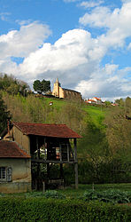 The church and surroundings in Montégut-Arros | |
show Location of Montégut-Arros | |
 Montégut-Arros | |
| Coordinates: 43°22′57″N 0°13′25″E / 43.3825°N 0.2236°ECoordinates: 43°22′57″N 0°13′25″E / 43.3825°N 0.2236°E | |
| Country | France |
| Region | Occitanie |
| Department | Gers |
| Arrondissement | Mirande |
| Canton | Mirande-Astarac |
| Government | |
| • Mayor (2008–2014) | Christian Cachalou |
| Area 1 | 15.29 km2 (5.90 sq mi) |
| Population (Jan. 2018)[1] | 288 |
| • Density | 19/km2 (49/sq mi) |
| Time zone | UTC+01:00 (CET) |
| • Summer (DST) | UTC+02:00 (CEST) |
| INSEE/Postal code | 32283 /32730 |
| Elevation | 170–334 m (558–1,096 ft) (avg. 180 m or 590 ft) |
| 1 French Land Register data, which excludes lakes, ponds, glaciers > 1 km2 (0.386 sq mi or 247 acres) and river estuaries. | |


Montégut-Arros is a commune in the Gers département in southwestern France.
Geography[]

Montégut-Arros and its surrounding communes
Population[]
Its inhabitants are known as Montégutois (male) or Montégutoise (female).[2]
| Year | Pop. | ±% |
|---|---|---|
| 1962 | 333 | — |
| 1968 | 340 | +2.1% |
| 1975 | 335 | −1.5% |
| 1982 | 350 | +4.5% |
| 1990 | 328 | −6.3% |
| 1999 | 286 | −12.8% |
| 2008 | 295 2010 | — |
| 289 | — |
See also[]
- Communes of the Gers department
References[]
- ^ "Populations légales 2018". INSEE. 28 December 2020.
- ^ Nom des habitants des communes françaises on the website Habitants.fr. Retrieved 8 November 2013.
| Wikimedia Commons has media related to Montégut-Arros. |
| show Communes of the Gers department |
|---|
This Gers geographical article is a stub. You can help Wikipedia by . |
Categories:
- Communes of Gers
- Gers geography stubs