Saint-Germé
Saint-Germé | |
|---|---|
 The church of Saint-Germé | |
show Location of Saint-Germé | |
 Saint-Germé | |
| Coordinates: 43°40′52″N 0°08′43″W / 43.6811°N 0.1453°WCoordinates: 43°40′52″N 0°08′43″W / 43.6811°N 0.1453°W | |
| Country | France |
| Region | Occitanie |
| Department | Gers |
| Arrondissement | Mirande |
| Canton | Adour-Gersoise |
| Government | |
| • Mayor (2008–2014) | Lionel Granier |
| Area 1 | 9.55 km2 (3.69 sq mi) |
| Population (Jan. 2018)[1] | 497 |
| • Density | 52/km2 (130/sq mi) |
| Time zone | UTC+01:00 (CET) |
| • Summer (DST) | UTC+02:00 (CEST) |
| INSEE/Postal code | 32378 /32400 |
| Elevation | 89–110 m (292–361 ft) (avg. 102 m or 335 ft) |
| 1 French Land Register data, which excludes lakes, ponds, glaciers > 1 km2 (0.386 sq mi or 247 acres) and river estuaries. | |


Saint-Germé is a commune in the Gers department in southwestern France.
Geography[]
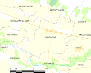
Saint-Germé and its surrounding communes
Population[]
| Year | Pop. | ±% |
|---|---|---|
| 1962 | 511 | — |
| 1968 | 508 | −0.6% |
| 1975 | 523 | +3.0% |
| 1982 | 488 | −6.7% |
| 1990 | 471 | −3.5% |
| 1999 | 443 | −5.9% |
| 2008 | 501 | +13.1% |
See also[]
- Communes of the Gers department
References[]
- ^ "Populations légales 2018". INSEE. 28 December 2020.
| Wikimedia Commons has media related to Saint-Germé. |
| show Communes of the Gers department |
|---|
This Gers geographical article is a stub. You can help Wikipedia by . |
Categories:
- Communes of Gers
- Gers geography stubs