Castelnavet
Castelnavet | |
|---|---|
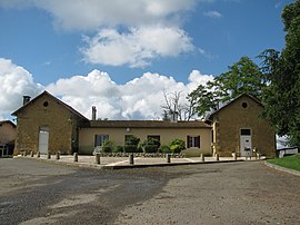 The town hall in Castelnavet | |
show Location of Castelnavet | |
 Castelnavet | |
| Coordinates: 43°40′28″N 0°07′50″E / 43.6744°N 0.1306°ECoordinates: 43°40′28″N 0°07′50″E / 43.6744°N 0.1306°E | |
| Country | France |
| Region | Occitanie |
| Department | Gers |
| Arrondissement | Mirande |
| Canton | Adour-Gersoise |
| Government | |
| • Mayor (2008–2014) | Michel Sansot |
| Area 1 | 18.06 km2 (6.97 sq mi) |
| Population (Jan. 2018)[1] | 131 |
| • Density | 7.3/km2 (19/sq mi) |
| Time zone | UTC+01:00 (CET) |
| • Summer (DST) | UTC+02:00 (CEST) |
| INSEE/Postal code | 32081 /32290 |
| Elevation | 125–245 m (410–804 ft) (avg. 305 m or 1,001 ft) |
| 1 French Land Register data, which excludes lakes, ponds, glaciers > 1 km2 (0.386 sq mi or 247 acres) and river estuaries. | |


Castelnavet is a commune in the Gers department in southwestern France.
Geography[]
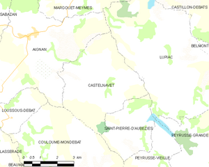
Castelnavet and its surrounding communes
Population[]
| Year | Pop. | ±% |
|---|---|---|
| 1962 | 250 | — |
| 1968 | 224 | −10.4% |
| 1975 | 201 | −10.3% |
| 1982 | 154 | −23.4% |
| 1990 | 153 | −0.6% |
| 1999 | 155 | +1.3% |
| 2008 | 146 | −5.8% |
See also[]
- Communes of the Gers department
References[]
- ^ "Populations légales 2018". INSEE. 28 December 2020.
| Wikimedia Commons has media related to Castelnavet. |
| show Communes of the Gers department |
|---|
This Gers geographical article is a stub. You can help Wikipedia by . |
Categories:
- Communes of Gers
- Gers geography stubs