Mongausy
Mongausy | |
|---|---|
 Coat of arms | |
show Location of Mongausy | |
 Mongausy | |
| Coordinates: 43°30′31″N 0°48′25″E / 43.5086°N 0.8069°ECoordinates: 43°30′31″N 0°48′25″E / 43.5086°N 0.8069°E | |
| Country | France |
| Region | Occitanie |
| Department | Gers |
| Arrondissement | Auch |
| Canton | Val de Save |
| Government | |
| • Mayor (2008–2014) | Norbert Dupuy |
| Area 1 | 7.41 km2 (2.86 sq mi) |
| Population (Jan. 2018)[1] | 79 |
| • Density | 11/km2 (28/sq mi) |
| Time zone | UTC+01:00 (CET) |
| • Summer (DST) | UTC+02:00 (CEST) |
| INSEE/Postal code | 32270 /32220 |
| Elevation | 177–305 m (581–1,001 ft) (avg. 297 m or 974 ft) |
| 1 French Land Register data, which excludes lakes, ponds, glaciers > 1 km2 (0.386 sq mi or 247 acres) and river estuaries. | |


Mongausy is a commune in the Gers department in southwestern France.
Geography[]
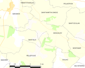
Mongausy and its surrounding communes
Population[]
| Year | Pop. | ±% |
|---|---|---|
| 1962 | 108 | — |
| 1968 | 83 | −23.1% |
| 1975 | 89 | +7.2% |
| 1982 | 77 | −13.5% |
| 1990 | 75 | −2.6% |
| 1999 | 64 | −14.7% |
| 2008 | 76 | +18.8% |
See also[]
- Communes of the Gers department
References[]
- ^ "Populations légales 2018". INSEE. 28 December 2020.
| Wikimedia Commons has media related to Mongausy. |
| show Communes of the Gers department |
|---|
This Gers geographical article is a stub. You can help Wikipedia by . |
Categories:
- Communes of Gers
- Gers geography stubs