Saint-André, Gers
Saint-André | |
|---|---|
show Location of Saint-André | |
 Saint-André | |
| Coordinates: 43°33′48″N 0°51′25″E / 43.5633°N 0.8569°ECoordinates: 43°33′48″N 0°51′25″E / 43.5633°N 0.8569°E | |
| Country | France |
| Region | Occitanie |
| Department | Gers |
| Arrondissement | Auch |
| Canton | Val de Save |
| Intercommunality | Savès |
| Government | |
| • Mayor (2008–2014) | Léo Faure |
| Area 1 | 5.58 km2 (2.15 sq mi) |
| Population (Jan. 2018)[1] | 127 |
| • Density | 23/km2 (59/sq mi) |
| Time zone | UTC+01:00 (CET) |
| • Summer (DST) | UTC+02:00 (CEST) |
| INSEE/Postal code | 32356 /32200 |
| Elevation | 175–246 m (574–807 ft) (avg. 184 m or 604 ft) |
| 1 French Land Register data, which excludes lakes, ponds, glaciers > 1 km2 (0.386 sq mi or 247 acres) and river estuaries. | |


Saint-André is a commune in the Gers Department in southwestern France.
Geography[]
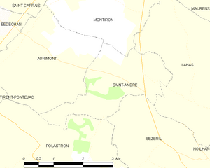
Saint-André and its surrounding communes
Population[]
| Year | Pop. | ±% |
|---|---|---|
| 1962 | 115 | — |
| 1968 | 101 | −12.2% |
| 1975 | 98 | −3.0% |
| 1982 | 92 | −6.1% |
| 1990 | 95 | +3.3% |
| 1999 | 76 | −20.0% |
| 2008 | 89 | +17.1% |
See also[]
- Communes of the Gers department
References[]
- ^ "Populations légales 2018". INSEE. 28 December 2020.
| Wikimedia Commons has media related to Saint-André (Gers). |
| show Communes of the Gers department |
|---|
This Gers geographical article is a stub. You can help Wikipedia by . |
Categories:
- Communes of Gers
- Gers geography stubs